|
|
|
|
Page updated: 28 May 2004
This page accompanies a Data and Analysis Note in the Journal of Geophysical Research (1997) entitled Digital Isochrons of the World's Ocean Floor, see list of authors below:
|
|
|
|
FTP |
POSTERS |
This page accompanies a Data and Analysis Note in the Journal of Geophysical Research (1997) entitled Digital Isochrons of the World's Ocean Floor by the following authors:
We have created a digital age grid of the ocean floor with a grid node interval of 6 arc-minutes using a self-consistent set of global isochrons and associated plate reconstruction poles. The age at each grid node was determined by linear interpolation between adjacent isochrons in the direction of spreading. Ages for ocean floor between the oldest identified magnetic anomalies and continental crust were interpolated by estimating the ages of passive continental margin segments from geological data and published plate models.
We have constructed a grid with error estimates for each grid cell as a function of (1) the error of ocean floor ages identified from magnetic anomalies along ship tracks and the age of the corresponding grid cells in our age grid, (2) the distance of a given grid cell to the nearest magnetic anomaly identification, and (3) the gradient of the age grid, i.e. larger errors are associated with high age gradients at fracture zones or other age discontinuities.
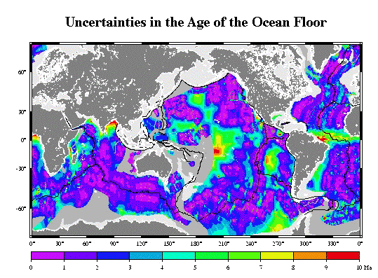 Uncertainties in the Ages of the World's Ocean Floor
 The gridded ages of the ocean floor are based on a digital set of isochrons. The isochrons are based on a large number of marine magnetic anomaly data, satellite altimetry data, and a self-consistent plate model.
 Selected
Isochrons of the ocean floor
Selected
Isochrons of the ocean floorThe finite rotation poles that the isochrons are based on and the references to the magnetic anomaly and fracture zone data are documented in : A global isochron chart by J.-Y. Royer, R.D. Müller, L.M. Gahagan, L.A. Lawver, C.L. Mayes, D. Nürnberg and J.G. Sclater.
University of Texas Institute for Geophysics Technical Report No. 117, 1992.
The digital age and error grids, files of continent-ocean boundaries and present-day
plate boundaries, a C-program to adapt the grid to new timescales, can be obtained
from a public ftp site at ftp://ftp.es.usyd.edu.au/pub/agegrid/.
Copies of a colored, shaded relief map (~34 x 60 in. large) of the gridded ages can be obtained for US $40 within the USA from: Geological Data Center
Scripps Institution of Oceanography
9500 Gilman Drive
La Jolla, CA 92093-0223,
Ph. (619) 534 2752.
Outside the USA copies of the map can be obtained for CAN $50 from: Geophysical
Data Center
Geological Survey of Canada
1 Observatory Crescent
Ottawa, Ontario K1A 0Y3
Canada
Ph. (613) 995 5326.
The US National Geophysical Data Center (NGDC) has produced a color
poster (24"x32") with 3-D perspectives (NGDC
Report MGG-12). For copies and information, contact: ngdc.info@noaa.gov
NOAA National Geophysical Data Center Mail code E/CG3
325 Broadway
Boulder, CO 80305-3328
E-mail: ngdc.info@noaa.gov
Abstract
Introduction
Ocean Floor Isochrons and Plate Boundaries
Interpolation of Isochrons and Gridding
Accuracy
Conclusions
Acknowledgments
References
Addresses and e-mail of authors
We have created a digital age grid of the ocean floor with a grid node interval of 6 arc-minutes using a self-consistent set of global isochrons and associated plate reconstruction poles. The age at each grid node was determined by linear interpolation between adjacent isochrons in the direction of spreading. Ages for ocean floor between the oldest identified magnetic anomalies and continental crust were interpolated by estimating the ages of passive continental margin segments from geological data and published plate models. We have constructed an age grid with error estimates for each grid cell as a function of (1) the error of ocean floor ages identified from magnetic anomalies along ship tracks and the age of the corresponding grid cells in our age grid, (2) the distance of a given grid cell to the nearest magnetic anomaly identification, and (3) the gradient of the age grid, i.e. larger errors are associated with high age gradients at fracture zones or other age discontinuities. Future applications of this digital grid include studies of the thermal and elastic structure of the lithosphere, the heat loss of the Earth, ridge-push forces through time, asymmetry of spreading, and providing constraints for seismic tomography and mantle convection models.
The age of the ocean floor is an important parameter in the study of plate tectonic processes. An accurate digital age grid is essential for many studies, including plate kinematics, studies of plate driving forces, mantle dynamics, ocean floor roughness and paleoceanography. Several analog maps of the age of the ocean floor have been compiled using magnetic anomaly data [e.g., Sclater et al., 1981; Larson et al., 1985]. A digital version of the latter map was produced by Cazenave et al. [1988], at a grid interval of half a degree (approx. 55 km). Recent improvements in identifications of magnetic anomalies and plate kinematic models, especially aided by dense gravity data from satellite altimetry, permit a more detailed description of the spreading process, and have initiated the construction of a more detailed age grid.
We have constructed a global set of isochrons for the ocean basins corresponding to magnetic anomalies 5, 6, 13, 18, 21, 25,31, 34, M0, M4, M10, M16, M21, and M25 based on a global plate reconstruction model, magnetic anomaly identifications and fracture zones [see also Royer et al., 1992]. The geomagnetic time scale of Cande and Kent [1995] was used for anomalies younger than chron 34 (83 Ma), the time scale from Gradstein et al. [1994] for older times. Isochrons were constructed by plotting reconstructed magnetic anomaly and fracture zone picks, as well as selected small circles computed from stage rotation poles for each isochron time, keeping one plate fixed. Then best-fit continuous isochrons were constructed, connected by transforms, in the framework of one fixed plate [see also Müller et al., 1991]. A complete set of isochrons for all conjugate plate pairs was derived by rotation of every isochron to their present day position.
Construction of a complete age grid also requires knowledge of the present day plate boundary geometry. The boundaries shown in Figure 1 have been compiled based on a marine gravity grid from Geosat exact repeat mission, Geodetic Mission, and ERS-1 satellite altimetry data [Sandwell et al., 1994], bathymetric data, and Earthquake epicenters. There is a significant area of ocean floor that is older than the oldest mapped isochrons. In order to estimate ages for the oldest ocean floor in ocean basins bounded by passive margins, we assigned ages to continental margin segments based on geological data and published plate models. The regional boundaries between continental and oceanic crust have been compiled in Müller and Roest [1992] (North and central North Atlantic), Nürnberg and Müller [1992] (South Atlantic), and Royer et al. [1992] (Indian Ocean). South of 60°S a dense grid of Geosat Geodetic Mission data [Sandwell et al., 1994] has been used to better locate boundaries between continental and oceanic crust in remote areas such as the Antarctic continental margin.
In order to create a smooth grid of ocean floor ages that maintains all sharp age discontinuities at fracture zones, we first create a set of densely interpolated isochrons. We assume that the spreading direction between two adjacent isochrons is given by a constant stage pole of motion, derived from our plate kinematic model. We also assume that the spreading velocity between two adjacent isochrons is constant, and that consequently the age varies linearly in the direction of spreading on a given ridge flank. To simplify the calculations, each pair of adjacent isochrons is transformed to a coordinate system in which the stage pole of motion between the two isochrons is moved onto the geographic north pole [Roest et al.,1992]. Then intermediate isochrons were linearly interpolated along plate flow-lines. This is equivalent to interpolation along small circles about the stage pole. The complete set of isochrons for each stage was subsequently rotated back into the geographic reference frame. This was done for each isochron pair on each plate pair.
To interpolate the ages onto a regular grid, we assume that the isochrons are continuous, which is implemented by densely interpolating between observation points along each isochron. A minimum curvature routine is used to obtain age values on a regular grid at a resolution of 0.1 degrees, equivalent to 6 arc-minutes. Areas of the ocean floor with insufficient data coverage were blanked out in the grid. We included data from selected back-arc basins, where data coverage is sufficient and available to us. The resolution of our grid for these areas is typically reduced by a factor of 10 with respect to the oceanic grid, i.e. the resolution in back-arc basins does not exceed 1 degree, and provides merely a rough estimate of the age distribution in these basins. The resulting grid is shown in Figure 1a .
The accuracy of the age grid varies considerably due to the spatially irregular distribution of ship track data in the oceans. Other sources of errors are given by our chosen spacing of isochrons as listed before, between which we interpolated linearly. These stages are especially long during long time intervals without changes in the polarity of the Earth's magnetic field such as the Cretaceous Magnetic Quiet Zone from about 118 to 83 Ma. We assume that age grid errors depend on the distance to the nearest data points and the proximity to fracture zones. In order to estimate the accuracy of our age grid, we construct a grid with age-error estimates for each grid cell dependent on (1) the error of ocean floor ages identified from magnetic anomalies along ship tracks and the age of the corresponding grid cells in our age grid, (2) the distance of a given grid node to the nearest magnetic anomaly identification, and (3) the gradient of the age grid, i.e. larger errors are associated with high age gradients across fracture zones or other age discontinuities. The latter also reflects that, due to the interpolation process, uncertainty in the magnetic anomaly will induce larger age errors in regions of slow spreading rates than in regions of fast spreading rates.
We first compute the age differences between ~30000 interpreted magnetic anomaly ages and the ages from our digital age grid, and investigate the size and distribution of the resulting age errors. We find that the majority of errors are smaller than 1 m.y. and errors larger than 10 m.y. are mostly due to erroneously labeled or interpreted data points. Therefore we set an upper limit for acceptable errors as 10 m.y. As a lower limit we arbitrarily choose 0.5 m.y., since we do not expect to resolve errors smaller than 0.5 m.y. given the uncertainty in the timescales used. We grid the remaining age errors by using continuous curvature splines in tension.
The constraints on the ages in our global age grid generally decrease
with increasing distance to the nearest interpreted magnetic anomaly data
point. Areas without interpreted magnetic anomalies include east-west spreading
mid-ocean ridges in low latitudes such a the equatorial Atlantic ocean,
where the remanent magnetic field vectors are nearly parallel to the mid-ocean
ridge and cause very small magnetic anomalies, and areas with sparse data
coverage such as some remote areas in the southern ocean. In order to address
the "tectonic reconstruction uncertainties" for these areas, we create
a grid containing the distance of a given grid cell to the nearest data
point, ranging from zero at the magnetic anomaly data points to 10 at distances
of 1000 km and larger. We smooth this grid using a cosine arch filter (5°
full width) and add the result to the initial splined grid of age errors.
Fracture zones are usually several tens of km wide, containing highly fractured
and/or serpentinized ocean crust. Age estimates may be uncertain especially
near large-offset fracture zones, which are more severely affected by changes
in spreading direction than small-offset fracture zones. Consequently, our age
estimates along large-offset fracture zones may be more uncertain than at small-offset
fracture zones or on "normal" ocean crust. Large-offset fracture zones are easily
identified in the age grid by computing the gradient of the age grid. We identify
the age gradients associated with medium- to large offset fracture zones, set
the gradients of "normal" ocean crust to zero, smooth the result with a 3x3
moving average filter, and scale the grid to range from one to two. After multiplying
the error grid with the smoothed age gradients along fracture zones, we have
not altered the errors associated with "normal" ocean floor, and increased the
errors at fracture zones by a factor between one and two, depending on the magnitude
of the age gradient. The resulting grid of age uncertainties is shown in Figure
1b .
The digital age grid presented here is the first of its kind, because (1) in the past ages of the ocean floor have only been available on analog maps, with the exception of a digitized version of Larson et al.'s [1985] age map produced by Cazenave et al. [1988] at a relatively coarse grid interval of 0.5°, (2) our grid is based on a self-consistent global plate model, and (3) it is accompanied by a grid estimating the uncertainties of the gridded ages. A shortcoming of our error analysis at present is that it does not include the uncertainties of the plate rotations. We hope to include this parameter in the next age grid generation.
This work was made possible by the contributors to the former Paleoceanographic Mapping Project (POMP, University of Texas, Austin) who released data that served as partial input for constructing the isochrons, POMP industry sponsors for financial support to RDM, LMG and JYR, and by the PLATES industry sponsors through support to LMG. Construction of the age grid was started at the Scripps Institute of Oceanography while the senior author was supported by a graduate and a post-doctoral fellowship. JYR acknowledges support by the CNRS (Centre National de la Recherche Scientifique). CONOCO/Canada provided funds for publishing color figures. The GMT software system from P. Wessel and W.H.F. Smith was invaluable in performing the age error analysis, and for producing the Figures.
Cande, S.C. and D.V. Kent, Revised calibration of the geomagnetic time scale for the late Cretaceous and Cenozoic, J. Geophys. Res., 100, 6093-6098, 1995.
Cazenave, A., K. Domihn, M. Rabinowicz, and G. Ceuleneer, Geoid and depth anomalies over ocean swells and troughs: evidence of an increasing trend of the geoid to depth ratio with age of plate, J. Geophys. Res., 93, 8064 ­p; 8077, 1988.
Larson, R.L., W.C. Pitman, X. Golovchenko, S.D. Cande, J.F. Dewey, W.F.
Haxby, and J.L.
LaBrecque, Bedrock Geology of the World, Freeman, New York, 1985.
Müller, R.D. and Roest, W.R., Fracture zones in the North Atlantic from combined Geosat and Seasat data: Jour. of Geophys. Res., 97, p. 3337-3350, 1992.
Müller, R. D., D.T. Sandwell, B.E. Tucholke, J. G. Sclater, and P.R. Shaw, Depth to basement and geoid expression of the Kane Fracture Zone: a comparison, Mar. Geophys. Res., 13, 105-129, 1991.
Nürnberg, D. and R.D. Müller, The Tectonic evolution of the South Atlantic from Late Jurassic to Present, Tectonophys., 191, 27-53, 1991.
Gradstein, F.M., F.P. Agterberg, J.G. Ogg, J. Hardenbol, P. van Veen, J. Thierry, and Z. Huang, A Mesozoic timescale, J. Geophys. Res., 99, 24051-24074, 1994.
Roest, W.R., R.D. Müller, and J. Verhoef, Age of the ocean floor: A digital data set for the Labrador Sea and Western North Atlantic, Geoscience Canada, 19, 27-32, 1992.
Royer, J.-Y., R.D. Müller, L.M. Gahagan, L.A., Lawver, C.L. Mayes, D. Nürnberg, and J.G. Sclater, A global isochron chart, Univ. of Texas Inst. for Geophysics Tech. Rep., 117, 1992.
Sandwell, D.T., M. Yale, and W.H.F. Smith, ERS-1 Geodetic Mission Reveals Detailed tectonic structures, EOS Trans. Am. Geophys. Union, 75, 155, 1994.
Sclater, J.G., B. Parsons, and C. Jaupart, Oceans and continents: similarities and differences in the mechanism of heat loss, Jour. of Geophys.Res., 86, 11535 ­p; 11552, 1981.
L. M. Gahagan, Institute for Geophysics, University of Texas, 8701 Mopac Boulevard, Austin, TX 78759-8345 (e-mail: lisa@utig.ig.utexas.edu)
R. D. Müller, School of Geosciences,, Building F05, University of Sydney, N.S.W. 2006, Australia (e-mail: dietmar@geosci.usyd.edu.au)
W. R. Roest, Institut français de recherche pour l'exploitation de la mer (IFREMER), email: Walter.Roest@ifremer.fr .
J.-Y. Royer, Université de Bretagne Occidentale (UBO), email: jyroyer@univ-brest.fr.
J. G. Sclater,, Scripps Institution of Oceanography, UCSD, 9500 Gilman Drive,
La Jolla, CA 92093-0215 (e-mail: sclater@bullard.ucsd.edu)
The digital grid globalage_1.6.grd is a binary grid registered GMT NETCDF grd file which can be manipulated and plotted with Wessel and Smith's GMT software system.
We provide a C-program named grdage_cor.c which can be used to update the agegrid using different timescales. A Makefile is included to compile the program (it depends on the GMT and NETCDF libraries which you need to have installed). The program reads a grid file in default GMT grd-format and a table which includes the mapping of old to new ages (see example age_conv.tab).
The file age.cpt is a GMT color pallette file which can be used to plot the agegrid using the GMT software.
---------
This program should give the following output for globalage_1.3.bint:
Average age, min, max: 61.7434425 0. 179.979996
The file isochrons.dat contains the seafloor spreading isochrons the age agrid is based on. The data are stored in PLATES format. Each data "string" starts with a 2 line "header". The 1st line contains 3 integer numbers you can ignore, and a geographic description of the data. The 2nd line contains a 3 digit plate ID (e.g. 301 = Eurasia), the age of the isochron, another age (default = 999.0), a data type descriptor (e.g. IS 5 = isochron at magnetic anomaly 5 time), the plate ID of the conjugate plate and a few other numbers you can ignore. A list of plate ID integers can be found in the file globalage_pid.lst.
The files platebound.dat and platebound_xr.dat contain present day plate boundaries and the location of extinct ridges, respectively, in the same format as above. Neither file is necessarily complete or correct. In case you have more up-to-date data for either present day or extinct plate boundaries which you may wish to share with us, please let us know.
In order to plot these data with the GMT software system, an awk script can be used to strip off the headers and create an mutliple segment GMT lat/lon file:
awk ' NF==3 && $1 != 99.0000 {
if ($2 < 0) $2 = $2 + 360;
if ($3 == 3) printf("> new string\n%s\t%s\n", $1, $2);
else printf("%s %s\n",$1,$2);
}' file_name.dat
Two tar files contain closed right-handed polygons of the major plates (plate_polygons.tar) and of the boundaries between oceanic and continental crust (cob_polygons.tar). All polygons are lat/lon ascii files without headers.
"cont" in the filename indicates that the polygon encloses continental crust while "ocean" in the filename indicates that the polygon encloses ocean crust within continental crust. The cob_polygons are (lat/lon format):
afr_cont_cob.yx |
African |
ant_cont_cob.yx |
Antarctica |
arctic_ocean_cob.yx |
Arctic Ocean |
aus_cont_cob.yx |
Australia |
car_ocean_cob.yx |
Caribbean |
cayman_ocean_cob.yx |
Caribbean (Cayman Trough) |
eur_cont_cob.yx |
Eurasia |
gulfmex_ocean_cob.yx |
Gulf of Mexico |
janmay_cont_cob.yx |
Jan Mayen |
madagas_cont_cob.yx |
Madagascar |
nam_cont_cob.yx |
North America |
nzealand_cont_cob.yx |
New Zealand |
s_georgia_cont_cob.yx |
South Georgia Microcontinent |
sam_cont_cob.yx |
South America |
seychel_cont_cob.yx |
Seychelles |
afr_plate.yx |
Africa |
ant_plate.yx |
Antarctica |
arab_plate.yx |
Arabia |
aus_plate.yx |
Australia |
car_plate.yx |
Caribbean |
coco_plate.yx |
Cocos Plate |
east_plate.yx |
Easter Microplate |
eur_plate.yx |
Eurasia |
ind_plate.yx |
India |
juan_plate.yx |
Juan de Fuca Plate |
nam_plate.yx |
North America |
naz_plate.yx |
Nazca Plate |
pac_plate.yx |
Pacific Plate |
sam_plate.yx |
South America |
Permission is granted to use and freely distribute the age grid.
Send any inquiries about the age grid to: A/Prof Dietmar Müller email at dietmar@geosci.usyd.edu.au.
The University of Sydney
School of Geosciences
Edgeworth David Building F05
N.S.W. 2006
AUSTRALIA
Introduction
Color images of plate reconstruction with isochrons
References for coastlines, sutures, continental margins
References for plate boundaries
References for satellite interpretations
References for ship-track data by region
Finite rotations used to reconstruct isochrons
References
The Paleoceanographic Mapping Project (POMP) began in 1984 as a global, plate reconstruction project at the University of Texas at Austin Institute for Geophysics (UTIG). Sponsored by a consortium of oil companies, the original goals of POMP were to:
build a digital, global data base of coastlines, plate boundaries, and marine magnetic and tectonic data,
develop software for digitizing, manipulating, and reconstructing the data,
develop a global model of plate motions through time based on the data base.
By the end of the project in April, 1991, POMP had succeeded in achieving these goals. POMP had provided its sponsors with both the data base and a comprehensive, self-consistent plate motion model which described the Mesozoic and Cenozoic evolution of the world's major ocean basins. The data base included tectonic lineations interpreted from Seasat and Geosat altimeter data, which permitted greatly improved reconstructions. The accuracy of the reconstructions exceeded original expectations, and a well-constrained plate model of the major ocean basins was developed.
In July of 1989, members of the POMP research team presented the POMP database and plate model at the 28th International Geological Congress in Washington, D.C. Included in their presentation was a series of isochrons constructed using the data base and plate model. This report is meant to serve as documentation of that presentation and of some of the results of POMP itself.
Figure 1 shows magnetic and fracture zone lineations from 1) ship data in the POMP database (data sources are listed by region below) and 2) and from Seasat and Geosat satellite altimetry data.
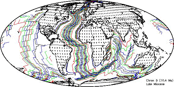
Figure 3 is a present-day map of isochrons and the current plate boundaries dividing the tectonic plates. Plate reconstructions and isochrons were constructed for the following anomaly times (chrons): 5 (9.7 Ma), 6 (20.1 Ma), 13 (33.1 Ma), 18 (40.1 Ma), 21 (47.9 Ma), 25 (55.9 Ma), 31 (67.7 Ma), 34 (83.5 Ma), M0 (120.4 Ma), M4 (126.7 Ma), M10N (131.9 Ma), M16 (139.6 Ma), M21 (147.7 Ma), M25 (154.3 Ma), M29 (168.0 Ma), and 180 Ma.
Barker and Lawver, 1986
Bott, 1987
Buffler et al., 1981
Case and Holcombe, 1980
Dunbar and Sawyer, 1986
Eldholm and Thiede, 1987
Emery and Uchupi, 1984
Fischer et al., 1971
General Bathymetric Chart of the Oceans, 1981
Hayes and Taylor, 1978
Johnson and Holmes, 1989
Kroenke et al., 1983
Ladd, 1974
Larsen, 1984
New Zealand Geological Survey, 1972
Nürnberg and Müller, 1991
Otsuki and Ehiro, 1979
Piccirillo et al., 1988
Roest and Srivastava, 1989
Royer, 1987
Royer and Sandwell, 1989
Srivastava and Roest, 1989
Veevers, 1986
Veevers et al., 1985
World Data Bank #2 (CIA), 19??
Ziegler, 1982
Barker, 1982
Cande et al., 1982
Cande et al., 1988
Cochran, 1981
Curray et al., 1979
Fischer et al., 1971
Guennoc et al., 1988
Hayes and Taylor, 1978
Hamilton, 1978
Hill and Hayward, 1988
Jennings, 1961
Johnson and Holmes, 1989
Klitgord and Schouten, 1986
Klitgord and Mammerickx, 1983
Larson et al., 1985
Mejorada, 1976
New Zealand Geological Survey, 1972
Otsuki and Ehiro, 1979
Packhorn, 1982
Rosencrantz et al., 1988
Ross and Scotese, 1988
Royer et al., 1988
Searle, 1980
Gahagan et al., 1988
Mayes et al., 1990
Nürnberg & Müller , 1991
Royer et al., 1989
Canadian Hydrographic Service, 1981
Klitgord and Schouten, 1986
Ohta, 1982
Perry et al., 1985
Barker and Lawver, 1986
Bott, 1987
Canadian Hydrographic Service, 1981
Eldholm and Thiede, 1987
Emery and Uchupi, 1984
Hill and Hayward, 1988
Klitgord and Schouten, 1986
Larsen, 1984
Perry et al., 1985
Roest and Srivastava, 1989
Ziegler, P.A., 1982
Buffler et al., 1981
Case and Holcombe, 1980
Mejorada, P., 1976
Rosencrantz et al., 1988
Barker and Lawver, 1986
Cande et al., 1988
Emery and Uchupi, 1984
LaBrecque and Cande, 1986
LaBrecque and Hayes, 1979
Ladd, 1974
Martin et al., 1982
Nürnberg and Müller,1991
Rabinowitz and LaBrecque, 1979
Barker and Lawver, 1986
Barker and Lawver, 1986
Bergh, pers. comm.
Bergh, 1987
Cochran, 1988
Cochran, 1981
Davies et al., 1974
Fisher et al., 1971
General Bathymetric Chart of the Oceans, 1981
Goodlad et al., 1982
Guennoc et al., 1988
Karasik et al., 1986
LaBrecque and Hayes, 1979
Larson et al., 1978
Liu et al., 1982
Markl, 1974
Markl, 1978
McKenzie and Sclater, 1971
Mohr and Zannettin, 1988
Norton and Sclater, 1979
Patriat, 1987
Patriat, 1987
Rabinowitz and LaBrecque, 1979
Royer et al., 1988
Royer and Sandwell, 1989
Schlich, 1982
Schlich et al., 1987
Sclater et al., 1976
Segoufin, 1981
Segoufin and Patriat, 1981
Tapscott et al., 1980
Veevers, 1986
Veevers et al., 1985
Vogt et al., 1983
Weissel and Hayes, 1972
Whitmarsh, 1974
Whitmarsh et al., 1974
Cande et al., 1978
Caress et al., 1988
Currie et al., 1982
Elvers et al., 1967
Elvers et al., 1972
Hilde et al., 1976
Klitgord and Mammerickx, 1982
Lonsdale, 1988
Mammerickx et al., 1976
Mammerickx et al., 1988
Mammerickx and Sharman, 1988
Nakanishi et al., 1989
Nakanishi et al., 1992
Raff and Mason, 1961
Sharman and Risch, 1988
Tamaki et al., 1979
Tamaki et al., 1979
Theberge, 1971
Handschumacher, 1976
Handschumacher et al.,1981
Herron,1972
Klitgord and Mammerickx, 1983
Mammerickx et al., 1980
Pardo-Casas and Molnar, 1987
Cande et al., 1982
Christofel and Falconer, 1972
Molnar et al., 1975
Weissel et al., 1977
Burns et al., 1973
Hamilton, 1978
Hayes and Taylor, 1978
Mammerickx et al., 1976
Central Africa paleomagnetic reference frame |
||||
|---|---|---|---|---|
0.0 |
0.00 |
0.00 |
0.00 |
|
14.0 |
0.00 |
92.00 |
5.00 |
Ziegler et al. 1983 |
44.0 |
0.00 |
113.00 |
12.00 |
Ziegler et al. 1983 |
60.0 |
0.00 |
126.00 |
10.00 |
Ziegler et al. 1983 |
75.0 |
0.00 |
129.00 |
17.00 |
Ziegler et al. 1983 |
93.0 |
0.00 |
151.00 |
20.00 |
Ziegler et al. 1983 |
131.0 |
0.00 |
156.00 |
35.00 |
Ziegler et al. 1983 |
175.0 |
0.00 |
166.00 |
36.00 |
Ziegler et al. 1983 |
192.0 |
0.00 |
172.00 |
31.00 |
Ziegler et al. 1983 |
North America to Northwest Africa |
||||
|---|---|---|---|---|
Age |
Lat |
Lon |
Angle |
Reference |
10.0 |
80.12 |
50.80 |
2.52 |
Müller et al. 1990 |
20.0 |
79.57 |
37.84 |
5.29 |
Klitgord & Schouten 1986 |
35.5 |
75.37 |
1.12 |
10.04 |
Müller et al. 1990 |
49.5 |
75.30 |
-3.88 |
15.25 |
Müller et al. 1990 |
59.0 |
79.68 |
-0.46 |
18.16 |
Müller et al. 1990 |
67.5 |
82.90 |
4.94 |
20.76 |
Müller et al. 1990 |
72.5 |
81.35 |
-9.15 |
22.87 |
Klitgord & Schouten 1986 |
74.3 |
80.76 |
-11.76 |
23.91 |
Klitgord & Schouten 1986 |
80.2 |
78.30 |
-18.35 |
27.06 |
Klitgord & Schouten 1986 |
84.0 |
76.55 |
-20.73 |
29.60 |
Klitgord & Schouten 1986 |
118.0 |
66.30 |
-19.90 |
54.25 |
Klitgord & Schouten 1986 |
126.0 |
66.13 |
-19.0 |
56.39 |
Klitgord & Schouten 1986 |
131.5 |
65.95 |
-18.50 |
57.40 |
Klitgord & Schouten 1986 |
141.5 |
66.10 |
-18.40 |
59.79 |
Klitgord & Schouten 1986 |
149.5 |
66.50 |
-18.10 |
61.92 |
Klitgord & Schouten 1986 |
156.5 |
67.15 |
-16.0 |
64.70 |
Klitgord & Schouten 1986 |
170.0 |
67.02 |
-13.17 |
72.10 |
Klitgord & Schouten 1986 |
175.0 |
66.95 |
-12.02 |
75.55 |
Klitgord & Schouten 1986 |
Greenland to North America |
||||
35.5 |
0.00 |
0.00 |
0.00 |
|
49.0 |
59.50 |
-92.00 |
-2.81 |
This paper |
56.0 |
54.91 |
-110.01 |
-4.00 |
Roest & Srivastava 1989 |
59.0 |
24.48 |
-137.25 |
-3.12 |
Roest & Srivastava 1989 |
61.0 |
20.61 |
-148.20 |
-3.27 |
Roest & Srivastava 1989 |
63.0 |
27.63 |
-149.41 |
-3.72 |
Roest & Srivastava 1989 |
69.0 |
43.94 |
-145.31 |
-4.92 |
Roest & Srivastava 1989 |
84.0 |
65.30 |
-122.45 |
-11.00 |
Roest & Srivastava 1989 |
92.0 |
66.60 |
-119.48 |
-12.20 |
Roest & Srivastava 1989 |
105.0 |
67.08 |
-118.96 |
-12.99 |
Roest & Srivastava 1989 |
118.0 |
67.50 |
-118.48 |
-13.78 |
Roest & Srivastava 1989 |
South America to Central Africa |
||||
1.9 |
60.00 |
-39.00 |
0.51 |
Cande et al. 1988 |
2.5 |
60.00 |
-39.00 |
0.77 |
Cande et al. 1988 |
3.9 |
60.00 |
-39.00 |
1.21 |
Cande et al. 1988 |
5.3 |
60.00 |
-39.00 |
1.78 |
Cande et al. 1988 |
6.7 |
60.00 |
-39.00 |
2.27 |
Cande et al. 1988 |
7.9 |
60.00 |
-39.00 |
2.76 |
Cande et al. 1988 |
8.9 |
60.00 |
-39.00 |
3.15 |
Cande et al. 1988 |
11.6 |
59.50 |
-38.00 |
4.05 |
Cande et al. 1988 |
14.9 |
59.50 |
-38.00 |
5.25 |
Cande et al. 1988 |
16.2 |
59.50 |
-38.00 |
5.75 |
Cande et al. 1988 |
17.6 |
59.50 |
-38.00 |
6.30 |
Cande et al. 1988 |
18.6 |
59.50 |
-38.00 |
6.70 |
Cande et al. 1988 |
19.4 |
59.50 |
-38.00 |
7.05 |
Cande et al. 1988 |
20.9 |
59.50 |
-37.75 |
7.60 |
Nürnberg & Müller 1991 |
22.6 |
59.50 |
-36.50 |
8.45 |
Cande et al. 1988 |
23.3 |
59.50 |
-37.00 |
8.80 |
Nürnberg & Müller 1991 |
25.5 |
59.00 |
-36.00 |
9.50 |
Cande et al. 1988 |
26.9 |
59.00 |
-36.00 |
10.00 |
Cande et al. 1988 |
28.2 |
58.00 |
-35.00 |
10.55 |
Cande et al. 1988 |
29.7 |
57.00 |
-35.00 |
11.05 |
Cande et al. 1988 |
31.2 |
57.00 |
-34.50 |
11.60 |
Nürnberg & Müller 1991 |
32.5 |
57.50 |
-35.00 |
12.15 |
Cande et al. 1988 |
35.3 |
57.50 |
-34.00 |
13.38 |
Cande et al. 1988 |
37.2 |
57.00 |
-33.50 |
14.10 |
Cande et al. 1988 |
38.1 |
57.00 |
-33.25 |
14.40 |
Nürnberg & Müller 1991 |
39.5 |
57.00 |
-33.00 |
15.05 |
Cande et al. 1988 |
41.3 |
57.50 |
-32.50 |
15.80 |
Cande et al. 1988 |
43.6 |
58.00 |
-32.00 |
17.00 |
Cande et al. 1988 |
44.7 |
57.50 |
-31.75 |
17.60 |
Cande et al. 1988 |
48.7 |
58.50 |
-31.50 |
19.07 |
Cande et al. 1988 |
51.9 |
59.00 |
-31.50 |
20.10 |
Cande et al. 1988 |
53.9 |
60.00 |
-32.00 |
20.75 |
Cande et al. 1988 |
55.1 |
60.00 |
-32.00 |
21.20 |
Cande et al. 1988 |
58.6 |
61.50 |
-32.50 |
22.30 |
Nürnberg & Müller 1991 |
60.2 |
61.50 |
-32.50 |
22.70 |
Cande et al. 1988 |
63.0 |
62.50 |
-33.00 |
23.55 |
Cande et al. 1988 |
64.3 |
63.00 |
-33.30 |
24.00 |
Cande et al. 1988 |
65.5 |
63.00 |
-33.30 |
24.30 |
Cande et al. 1988 |
66.7 |
63.00 |
-33.30 |
24.70 |
Cande et al. 1988 |
68.5 |
63.00 |
-33.50 |
25.40 |
Cande et al. 1988 |
71.4 |
63.00 |
-33.50 |
26.60 |
Cande et al. 1988 |
74.3 |
63.00 |
-33.50 |
27.90 |
Cande et al. 1988 |
80.2 |
63.00 |
-34.00 |
31.00 |
Cande et al. 1988 |
84.0 |
61.75 |
-34.00 |
33.50 |
Cande et al. 1988 |
118.7 |
50.10 |
-34.60 |
52.78 |
This paper |
121.0 |
50.00 |
-34.20 |
53.64 |
This paper |
126.5 |
49.30 |
-33.80 |
54.29 |
This paper |
131.5 |
49.10 |
-33.70 |
55.17 |
This paper |
245.0 |
49.10 |
-33.70 |
55.17 |
This paper |
Northwest Africa to Central Africa |
||||
0.0 |
0.00 |
0.00 |
0.00 |
|
84.0 |
0.00 |
0.00 |
0.00 |
|
118.7 |
8.80 |
98.70 |
0.37 |
This paper (fit) |
Northwest Africa to South America |
||||
118.7 |
50.00 |
-35.20 |
-52.90 |
This paper |
Eurasia to North America |
||||
10.0 |
65.38 |
133.58 |
-2.44 |
Lawver et al. 1990 |
20.0 |
68.92 |
136.74 |
-4.97 |
Lawver et al. 1990 |
36.0 |
65.64 |
136.95 |
-7.51 |
Lawver et al. 1990 |
49.0 |
67.19 |
137.74 |
-10.91 |
Srivastava & Roest 1989 |
56.0 |
62.60 |
140.81 |
-12.75 |
Srivastava & Roest 1989 |
59.0 |
63.14 |
141.66 |
-14.22 |
Srivastava & Roest 1989 |
69.0 |
64.84 |
143.96 |
-16.95 |
Srivastava & Roest 1989 |
80.0 |
66.17 |
147.74 |
-19.00 |
Srivastava & Roest 1989 |
84.0 |
66.54 |
148.91 |
-19.70 |
Srivastava & Roest 1989 |
92.0 |
66.67 |
150.26 |
-20.37 |
Srivastava & Roest 1989 |
105.0 |
66.85 |
152.34 |
-21.49 |
Srivastava & Roest 1989 |
118.0 |
68.99 |
154.75 |
-23.05 |
Srivastava & Roest 1989 |
145.0 |
68.99 |
154.75 |
-23.05 |
Srivastava & Roest 1989 |
170.0 |
69.10 |
156.70 |
-23.64 |
This paper |
Iberia (fixed) to Eurasia |
||||
0.0 |
0.00 |
0.00 |
0.00 |
|
30.0 |
90.00 |
0.00 |
0.00 |
(fixed) |
Iberia to Northwest Africa |
||||
30.0 |
31.4 |
-18.60 |
7.87 |
Srivastava & Tapscott 1986 (fit) |
133.2 |
31.4 |
-18.60 |
7.87 |
Srivastava & Tapscott 1986 |
Iberia to North America |
||||
133.2 |
70.30 |
-11.00 |
-51.50 |
calculated from Srivastava & Tapscott 1986 |
Porcupine plate to North America |
||||
10.0 |
65.38 |
133.58 |
-2.44 |
Lawver et al. 1990 |
20.0 |
68.92 |
136.74 |
-4.97 |
Lawver et al. 1990 |
36.0 |
65.64 |
136.95 |
-7.51 |
Lawver et al. 1990 |
49.0 |
58.75 |
142.49 |
-10.01 |
Srivastava & Roest 1989 |
56.0 |
59.21 |
143.14 |
-12.29 |
Srivastava & Roest 1989 |
59.0 |
60.10 |
143.68 |
-13.76 |
Srivastava & Roest 1989 |
69.0 |
62.31 |
145.52 |
-16.47 |
Srivastava & Roest 1989 |
80.0 |
63.90 |
148.92 |
-18.51 |
Srivastava & Roest 1989 |
84.0 |
64.35 |
149.97 |
-19.21 |
Srivastava & Roest 1989 |
92.0 |
64.55 |
151.19 |
-19.88 |
Srivastava & Roest 1989 |
105.0 |
64.82 |
153.08 |
-21.00 |
Srivastava & Roest 1989 |
118.0 |
67.13 |
155.32 |
-22.54 |
Srivastava & Roest 1989 |
Rockall to North America |
||||
10.0 |
65.38 |
133.58 |
-2.44 |
Lawver et al. 1990 |
20.0 |
68.92 |
136.74 |
-4.97 |
Lawver et al. 1990 |
36.0 |
65.64 |
136.95 |
-7.51 |
Lawver et al. 1990 |
49.0 |
63.62 |
141.96 |
-10.52 |
Srivastava & Roest 1989 |
56.0 |
54.86 |
143.39 |
-11.99 |
Srivastava & Roest 1989 |
59.0 |
56.24 |
143.78 |
-13.44 |
Srivastava & Roest 1989 |
69.0 |
59.05 |
147.21 |
-15.56 |
Srivastava & Roest 1989 |
80.0 |
69.31 |
152.06 |
-19.31 |
Srivastava & Roest 1989 |
84.0 |
72.29 |
154.49 |
-20.94 |
Srivastava & Roest 1989 |
92.0 |
73.95 |
156.24 |
-22.00 |
Srivastava & Roest 1989 |
118.0 |
75.32 |
159.61 |
-23.47 |
Srivastava & Roest 1989 |
Jan Mayen to Eurasia |
||||
36.0 |
0.00 |
0.00 |
0.00 |
|
42.7 |
64.90 |
-12.20 |
-22.60 |
This paper |
46.2 |
64.90 |
-12.30 |
-31.60 |
This paper |
49.0 |
64.30 |
-12.70 |
-37.30 |
Lawver et al. 1990 |
52.6 |
64.00 |
-12.90 |
-41.70 |
This paper |
54.7 |
63.10 |
-13.50 |
-40.90 |
This paper |
56.0 |
63.10 |
-13.50 |
-50.00 |
Lawver et al. 1990 |
Jan Mayen to Greenland (fit) |
||||
56.0 |
73.40 |
-10.80 |
-55.45 |
calculated from Lawver et al. 1990 |
245.0 |
73.40 |
-10.80 |
-55.45 |
calculated from Lawver et al. 1990 |
India to Central Indian Basin |
||||
|---|---|---|---|---|
Age |
Lat |
Lon |
Angle |
Reference |
0.0 |
90.00 |
0.00 |
0.00 |
This paper |
10.5 |
-8.70 |
76.90 |
2.75 |
This paper |
20.5 |
-0.90 |
74.60 |
6.77 |
This paper |
70.0 |
-0.90 |
74.60 |
6.77 |
This paper |
India to East Antarctica |
||||
70.0 |
13.00 |
7.20 |
-50.08 |
This paper |
80.2 |
8.20 |
11.00 |
-62.18 |
Royer & Sandwell 1989 |
84.0 |
7.80 |
10.90 |
-65.10 |
Royer & Sandwell 1989 |
India to Madagascar |
||||
84.0 |
17.50 |
22.60 |
-55.41 |
Royer & Sandwell 1989 |
100.0 |
18.20 |
24.60 |
-61.92 |
This paper |
115.0 |
19.40 |
27.10 |
-59.74 |
This paper |
140.0 |
19.10 |
31.20 |
-61.99 |
calculated from Lawver & Scotese 1987 |
India to East Antarctica (fit) |
||||
140.0 |
-4.40 |
16.70 |
-92.77 |
Lawver & Scotese 1987 |
Arabia to Central Africa |
||||
0.0 |
90.00 |
0.00 |
0.00 |
|
4.7 |
32.80 |
22.60 |
-1.89 |
LePichon & Gaullier 1988 |
13.0 |
32.20 |
22.60 |
-5.36 |
LePichon & Gaullier 1988 |
30.0 |
32.10 |
22.60 |
-6.36 |
LePichon & Gaullier 1988 |
Central Indian Basin to Australia |
||||
0.0 |
90.00 |
0.00 |
0.00 |
|
42.7 |
90.00 |
0.00 |
0.00 |
(fixed) |
Central Indian Basin to East Antarctica |
||||
42.7 |
16.60 |
29.90 |
-23.62 |
This paper |
46.2 |
16.30 |
28.50 |
-25.24 |
Royer & Sandwell 1989 |
50.4 |
14.90 |
26.00 |
-27.77 |
This paper |
56.1 |
12.30 |
21.50 |
-34.40 |
Royer & Sandwell 1989 |
64.3 |
9.70 |
17.40 |
-45.12 |
Royer & Sandwell 1989 |
68.5 |
9.40 |
13.70 |
-51.59 |
Royer & Sandwell 1989 |
80.2 |
8.20 |
11.00 |
-62.18 |
Royer & Sandwell 1989 |
84.0 |
7.80 |
10.90 |
-65.10 |
Royer & Sandwell 1989 |
Madagascar to Central Africa |
||||
115.0 |
90.00 |
0.00 |
0.00 |
|
118.7 |
5.40 |
-76.20 |
0.90 |
This paper |
123.0 |
5.40 |
-76.20 |
1.96 |
This paper |
126.5 |
5.40 |
-76.20 |
3.19 |
This paper |
129.4 |
5.40 |
-76.20 |
4.20 |
This paper |
141.9 |
5.40 |
-76.20 |
8.32 |
This paper |
149.9 |
4.00 |
-71.40 |
11.32 |
This paper |
165.0 |
-3.41 |
-81.70 |
19.73 |
Lawver and Scotese 1987 |
Mascarene Plateau to Madagascar |
||||
63.0 |
90.00 |
0.00 |
0.00 |
|
64.3 |
-15.10 |
49.90 |
-10.48 |
Patriat unpublished manuscript |
68.5 |
5.90 |
30.00 |
-12.74 |
Patriat unpublished manuscript |
73.4 |
4.30 |
32.80 |
-20.01 |
Patriat unpublished manuscript |
84.0 |
-4.50 |
46.00 |
-45.16 |
This paper |
96.0 |
-2.90 |
44.80 |
-50.00 |
This paper |
Australia to East Antarctica |
||||
0.0 |
90.00 |
0.00 |
0.00 |
|
10.5 |
13.10 |
36.10 |
-6.61 |
Royer & Chang 1991 |
20.5 |
15.40 |
32.70 |
-11.97 |
Royer & Chang 1991 |
35.5 |
13.80 |
33.40 |
-20.41 |
Royer & Chang 1991 |
42.7 |
16.60 |
29.90 |
-23.62 |
Royer & Sandwell 1989 |
46.2 |
15.10 |
31.30 |
-24.50 |
Royer & Sandwell 1989 |
56.1 |
12.50 |
31.70 |
-25.24 |
Royer & Sandwell 1989 |
68.5 |
8.70 |
33.20 |
-25.83 |
Royer & Sandwell 1989 |
80.2 |
6.20 |
35.10 |
-26.37 |
Royer & Sandwell 1989 |
84.0 |
4.90 |
35.80 |
-26.81 |
Royer & Sandwell 1989 |
96.0 |
1.00 |
38.00 |
-28.30 |
Royer & Sandwell 1989 |
130.0 |
-2.00 |
38.90 |
-31.50 |
Royer & Sandwell 1989 |
East Antarctica to Central Africa |
||||
0.0 |
90.00 |
0.00 |
0.00 |
|
10.5 |
8.20 |
-49.40 |
1.53 |
Royer & Chang 1991 |
20.5 |
10.70 |
-47.90 |
2.78 |
Royer & Chang 1991 |
35.5 |
12.00 |
-48.40 |
5.46 |
Royer & Chang 1991 |
46.2 |
11.40 |
-43.70 |
7.81 |
Royer et al. 1988 |
50.3 |
10.30 |
-42.90 |
8.77 |
Royer et al. 1988 |
56.1 |
6.70 |
-40.60 |
9.97 |
Royer et al. 1988 |
60.8 |
3.80 |
-39.70 |
10.63 |
Royer et al. 1988 |
64.3 |
0.60 |
-39.20 |
11.32 |
Royer et al. 1988 |
66.2 |
-0.40 |
-39.40 |
11.59 |
Royer et al. 1988 |
68.5 |
1.10 |
-41.60 |
11.84 |
Royer et al. 1988 |
73.6 |
-1.80 |
-41.40 |
13.47 |
Royer et al. 1988 |
80.2 |
-4.70 |
-39.70 |
16.04 |
Royer et al. 1988 |
84.0 |
-2.00 |
-39.20 |
17.85 |
Royer et al. 1988 |
118.7 |
-4.20 |
-29.10 |
42.80 |
This paper |
123.0 |
-4.60 |
-29.10 |
44.17 |
This paper |
141.9 |
-7.00 |
-26.90 |
50.70 |
This paper |
149.9 |
-4.70 |
-29.00 |
52.84 |
This paper |
165.0 |
-7.78 |
-31.42 |
58.00 |
Lawver & Scotese 1987 |
Kerguelen to East Antarctica |
||||
50.0 |
90.00 |
0.00 |
0.00 |
|
50.0 |
15.10 |
31.30 |
24.60 |
This paper |
155.0 |
15.10 |
31.30 |
24.60 |
This paper |
Marie Byrd Land to East Antarctica |
||||
|---|---|---|---|---|
Age |
Lat |
Lon |
Angle |
Reference |
95.0 |
90.00 |
0.00 |
0.00 |
|
130.0 |
62.27 |
21.84 |
13.27 |
Lawver & Scotese 1987 |
245.0 |
62.27 |
21.84 |
13.27 |
Lawver & Scotese 1987 |
Bellinghausen plate to Pacific |
||||
0.0 |
90.00 |
0.00 |
0.00 |
|
4.7 |
66.20 |
-83.50 |
- 4.13 |
Mayes et al. 1990 |
10.6 |
70.44 |
-78.84 |
-9.12 |
Mayes et al. 1990 |
25.8 |
73.13 |
-72.44 |
-19.52 |
Mayes et al. 1990 |
30.0 |
73.73 |
-69.54 |
-22.52 |
Mayes et al. 1990 |
35.9 |
73.67 |
-65.98 |
-26.68 |
Mayes et al. 1990 |
42.7 |
72.78 |
-64.61 |
-29.89 |
Mayes et al. 1990 |
49.6 |
72.09 |
-63.44 |
-33.93 |
Mayes et al. 1990 |
59.2 |
71.81 |
-60.67 |
-39.39 |
Mayes et al. 1990 |
65.1 |
70.77 |
-58.37 |
-45.52 |
Mayes et al. 1990 |
69.4 |
70.31 |
-56.34 |
-50.92 |
Mayes et al. 1990 |
74.0 |
69.92 |
-54.75 |
-56.33 |
Mayes et al. 1990 |
Lord Howe Rise to Australia |
||||
55.7 |
90.00 |
0.00 |
0.00 |
Weissel & Hayes 1977 |
60.5 |
-1.50 |
138.50 |
-2.55 |
Weissel & Hayes 1977 |
65.8 |
-5.50 |
140.50 |
-6.60 |
Weissel & Hayes 1977 |
72.7 |
-11.40 |
41.50 |
-12.75 |
Weissel & Hayes 1977 |
77.2 |
-14.00 |
142.00 |
-19.00 |
Weissel & Hayes 1977 |
84.0 |
-14.00 |
148.00 |
-23.34 |
This paper (fit) |
245.0 |
-14.00 |
148.00 |
-23.34 |
This paper |
Pacific to Marie Byrd Land |
||||
0.0 |
90.00 |
0.00 |
0.00 |
|
4.8 |
66.20 |
-83.50 |
4.13 |
Mayes et al. 1990 |
10.6 |
70.44 |
-78.84 |
9.12 |
Mayes et al. 1990 |
26.0 |
73.13 |
-72.44 |
19.52 |
Mayes et al. 1990 |
30.3 |
73.73 |
-69.54 |
22.52 |
Mayes et al. 1990 |
35.9 |
73.67 |
-65.98 |
26.68 |
Mayes et al. 1990 |
42.7 |
72.78 |
-64.61 |
29.89 |
Mayes et al. 1990 |
49.5 |
-73.42 |
122.78 |
-35.15 |
Stock & Molnar 1987 |
50.3 |
72.09 |
-63.44 |
33.93 |
Mayes et al. 1990 |
59.2 |
70.32 |
-63.45 |
36.77 |
Mayes et al. 1990 |
65.1 |
68.69 |
-63.47 |
39.88 |
Mayes et al. 1990 |
69.4 |
67.12 |
-63.02 |
4.53 |
Mayes et al. 1990 |
84.0 |
64.94 |
-62.49 |
53.09 |
Mayes et al. 1990 |
90.0 |
64.03 |
-56.96 |
57.65 |
Mayes et al. 1990 |
For times > 90 Ma, the Pacific plate is fixed to the global reference frame |
||||
90.0 |
64.00 |
-73.30 |
54.47 |
calculated from Mayes et al. 1990 |
Nazca to Pacific |
||||
0.0 |
90.00 |
0.00 |
0.00 |
|
4.8 |
58.86 |
-89.43 |
-6.60 |
Mayes et al. 1990 |
10.6 |
60.13 |
-89.76 |
-15.18 |
Mayes et al. 1990 |
20.5 |
64.50 |
-91.50 |
-30.70 |
calculated from Mayes et al. 1990 |
26.0 |
65.41 |
-92.00 |
-39.35 |
Mayes et al. 1990 |
26.0 |
38.80 |
-84.30 |
-20.79 |
This paper |
Vancouver to Pacific |
||||
0.0 |
90.00 |
0.00 |
0.00 |
|
10.4 |
72.00 |
6.40 |
-14.76 |
This paper |
20.5 |
82.60 |
4.60 |
-15.65 |
This paper |
35.3 |
88.50 |
-134.00 |
-34.99 |
This paper |
41.3 |
87.50 |
-161.00 |
-43.34 |
This paper |
48.8 |
86.50 |
-168.90 |
-51.80 |
This paper |
61.0 |
85.20 |
125.80 |
-59.54 |
This paper |
69.0 |
82.50 |
108.40 |
-66.24 |
This paper |
84.0 |
77.10 |
93.60 |
-75.91 |
This paper |
133.5 |
63.80 |
78.60 |
-108.58 |
This paper |
158.0 |
57.10 |
81.10 |
-121.36 |
This paper |
Cocos to Pacific |
||||
0.0 |
90.00 |
0.00 |
0.00 |
|
4.8 |
36.80 |
-108.60 |
-10.03 |
DeMets et al. 1990 |
10.4 |
34.00 |
-106.80 |
-22.73 |
This paper |
20.5 |
37.30 |
-113.30 |
-31.62 |
This paper |
20.5 |
55.40 |
-117.70 |
-42.28 |
This paper |
Izanagi to Pacific |
||||
84.0 |
90.0 |
0.0 |
0.0 |
Engebretson 1983 |
131.7 |
54.5 |
6.6 |
64.15 |
This paper |
141.9 |
64.7 |
15.7 |
68.33 |
This paper |
149.9 |
57.5 |
96.3 |
87.76 |
This paper |
156.6 |
60.5 |
80.8 |
79.43 |
This paper |
Barker, P. and Lawver, L., 1986, unpublished.
Barker, P.F., 1982, The Cenozoic subduction history of the Pacific margin of the Antarctic Peninsula: ridge crest-trench interactions, J. Geol. Soc. London, 139: 787-801.
Bergh, H.W., 1985, pers. comm.
Bergh, H.W., 1987, Underlying fracture zone nature of Astrid Ridge off Antarctica's Queen Maud Land, J. Geophys. Res., 92: 475-484.
Bott, M.N.P., 1987, The continental margin of central East Greenland in relation to North Atlantic plate tectonic evolution, J. Geol. Soc., London, 144: 561-568.
Buffler, R., Shaub., J. Huerta, R., Ibrahim, A. and Watkins, D., 1981, A model for the early evolution of the Gulf of Mexico Basin, Oceanol. Acta, C3, pp. 129-136.
Burns, R.E., Andrews, J.E., et al., 1973, Initial Reports of the Deep Sea Drilling Project, Leg XXI, Washington (U.S. Govt. Printing Office).
Canadian Hydrographic Service, 1981, General Bathymetric Map of the Oceans (GEBCO), scale 1:10,000,000.
Cande, S., LaBrecque, J.L., and Haxby, W.B., 1988, Plate kinematics of the South Atlantic: Chron 34 to present, J. Geophys. Res., 93(B11): 13479-13492.
Cande, S.C., Herron, E.M., and Hall, B.R., 1982, The early Cenozoic history of the southeast Pacific, Earth Planet. Sci. Letters, 57: 47-62.
Cande, S.C., Larson, R.L., and LaBrecque, J.L., 1978, Magnetic lineations in the Pacific Jurassic Quiet Zone, Earth Planet. Sci. Letters, 41: 434-440.
Caress, D.W., Menard, H.W., and Hey, R.N., 1988, Eocene reorganization of the Pacific-Farallon Spreading Center north of the Mendocino Fracture Zone, J. Geophys. Res., 93: 2813-2838.
Case, J. and Holcombe, T., 1980, Gologic-tectonic map of the Caribbean region, scale 1:2,500,000.
Christofel, D.A. and Falconer, R.F., 1972, Marine magnetic measurements in the southwest Pacific Ocean and the identification of new tectonic features, Antarctic Oceanology II -The Antarctic - New Zealand Sector.
Cochran, J. R., 1981, The Gulf of Aden: Structure and evolution of a young ocean basin and continental margin, J. Geophys. Res., 86: 263-287.
Cochran, J.R., 1988,The Somali Basin, Chain Ridge and the origin of the northern Somali Basin gravity and geoid low, J. Geophys. Res., 93(B10): 11,985 - 12,008.
Curray, J.R., Moore, D.G., Lawver, L.A., Emmel, F.J., Raitt, R.W., Henry, M., and Kieckhefer, R., 1979, Tectonics of the Andaman Sea and Burma, in J.S. Watkins, J. Montadert and P.W. Dickerson (editors), Geological and Geophysical Investigations of Continental Margins, pp. 189-198.
Currie, R.G., Seeman, D.A., and Riddihough, R.P., 1982, Total field magnetic anomaly offshore British Columbia, Geological Survey of Canada Open-File Report 828, scale 1:1,000,000.
Davies, T.A., Luyendyk, B.P., et al., 1974, Leg XXVI, Initial Reports of the Deep Sea Drilling Project, Washington (U.S. Govt. Printing Office).
DeMets, C., Gordon, R.G., Argus, D.F., and Stein, S., 1990, Current plate motions, Geophysical Journal International, 101: 425-478.
Dunbar, J. and Sawyer, D., 1986, Crust extension within the Gulf of Mexico: Implications for the breakup of Western Pangea, abs. from 1986 Geodynamics Symposium.
Eldholm, O. and Thiede, J., 1987, Summary and preliminary conclusions, OPD Leg 104: Proceedings, Ocean Drilling Program Initial Reports, Part A, 751-771.
Elvers, D.J., Mathewson, C.C., Kohler, R.E., and Moses, R.L., 1967, Systematic ocean surveys by the USC and GSS Pioneer 1961-1963: Coast and Geodetic Survey Operational Data Report C and GSDR-1, 19 P.
Emery, K.O. and Uchupi., E., 1984, The Geology of the Atlantic Ocean, Springer, New York, 1050 p. 9301
Fischer, A.G., et al., 1971, Initial Reports of the Deep Sea Drilling Project, Leg VI, Washington (U.S. Govt. Printing Office).
Fisher, R.L., Sclater, J.G. and McKenzie, D., 1971, Evolution of the Central Indian Ridge, GSA Bull. 82: 553-562.
Gahagan, L.M., Scotese, C.R., Royer, J.-Y., Sandwell, D.T., Winn, J.K., Tomlins, R.L., Ross, M.I., Newman, J.S., Müller, R.D., Mayes, C.L., Lawver, L.A., and Heubeck, C.E., 1988, Tectonic fabric map of the ocean basins from satellite altimetry data, Tectonophysics, 155: 1-26.
Goodlad, S.W., Martin, A.K., and Hartnady, C., 1982, Mesozoic magnetic anomalies in the southern Natal Valley, Nature, 295: 686-688.
Guennoc, P. Pautot, G., and Coutell, A., 1988, Surficial structures of the northern Red Sea azial valley from 23°N to 28°N: time and space evolution of neo-oceanic structures, Tectonophysics Special Issue on The Gulf of Suez and Red Sea rifting, 153: 1-23.
Hamilton, Warren, 1978, Tectonic map of the Indonesian region,USGS Survey, Map I-875-D, Reston, Va.
Handschumacher, D.W., 1976, Post-Eocene plate tectonics of the Eastern Pacific, in The Geophysics of the Pacific Ocean Basin and its Margins, in The Geophysics of the Pacific Ocean Basin and its Margins, AGU Monograph 19, ed.G.H.Sutton, et al., Washington: AGU, pp. 177-202.
Handschumacher, D.W., Pilger, R.H. Jr., Foreman, J.A., and Campbell, J.F., 1981, Structure and evolution of the Easter plate, GSA Memoir 154, pp. 63-76.
Hayes, D.E. and Taylor, B., 1978, A geophysical atlas of the East and Southeast Asian Seas, GSA Map and Chart Series MC-25,Washington, D.C.
Herron, E.M.,1972, Sea-floor spreading and the Cenozoic history of the east-central Pacific, GSA Bull., 83: 1671-1692.
Hilde, T.W.C., Isezki, Nobuhiro, and Wageman, J.M., 1976, in The Geophysics of the Pacific Ocean Basin and its Margins, p. 205-226 (Geophys. Mono. 19).
Hill, K.C. and Hayward, A.B., 1988, Structural constraints on the Tertiary plate tectonic evolution of Italy, Mar. Petr. Geol., 5: 2-16.
Jennings, C.W., 1961, Geologic map of California: Kingman sheet, scale 1:250,000, California Division of Mines and Geology, Sacramento, CA.
Johnson, H.P. and Holmes, M.L., 1989, Evolution in plate tectonics: The Juan de Fuca Ridge, in Winterer, E.L., Hussong, D.M. and Decker, R.W. (eds), The Eastern Pacific Ocean and Hawaii, The Geology of North America, Geological Society of America, Boulder, Colorado, Vol. N., pp. 73-91.
Karasik, A.M., Mercuryer, S.A., Mitin, L.I., Sochevanova, N.A., Yanovsky, V.N., 1986, Documents of the Academy of Science of the USSR, 286: 933-938.
Klitgord, K.D. and Mammerickx, J., 1983, Northern East Pacific Rise: Magnetic anomaly and bathymetric framework, J. Geophys. Res., 6725-6750.
Klitgord, K.D. and Schouten, H. 1986, Plate kinematics of the central Atlantic, in Vogt, P.R. and Tucholke, B.E., eds., The Western North Atlantic Region, GSA DNAG vol. M, pp. 351-378.
Kroenke, L.W., Jouannic, C. and Woodward, P., 1983, Bathymetry of the southwest Pacific, Geophysical Atlas of the southwest Pacific, chart 1, UNIGCP 110, United Nations ESCAP, New York.
LaBrecque, J.L. and Cande, S.C., 1986, Total intensity magnetic anomaly profiles, Northwest Ocean Margin Drilling Program, Regional Data Synthesis Series, Atlas 13, S. Atlantic Ocean and Adjacent Antarctic Continental Margin.
LaBrecque, J.L. and Hayes, D.E., 1979, Seafloor spreading history of the Agulhas Basin, Earth and Planet. Sci. Letters, 45: 411-428.
Ladd, J.W., 1974, South Atlantic seafloor spreading and Carribean tectonics, Ph.D.thesis, 251pp., Columbia University, New York, 1974.
Larsen, H.L., 1984, Geology of the East Greenland shelf: in Petroleum Geology of the North European Margin, Norweg. Pet. Soc., Graham & Trotman, pp. 329-339.
Larson R.L., Carpenter, G.B., and Diebold, J.B., 1978, A geophysical study of the Wharton Basin near the Investigator Fracture Zone, J. Geophys. Res., 83(B2): 773-782.
Larson, R.L., Pitman, W.C., Golobchenko, X., Cande, S.C., Dewey, J.F., Haxby, W.F. and LaBrecque, J.L., 1985, The Bedrock Geology of the World (color map), Freeman and Co., New York, NY.
Lawver, L.A., Müller, R.D., Srivastava, S.P., and Roest, W., 1990, The Opening of the Arctic Ocean, in Geologic History of the Polar Oceans: Arctic Versus Antarctic, U. Bleil and J. Thiede (eds.), from the NATO Symposium (October, 1988) in Bremen, West Germany, pp. 29-62.
Lawver, L.A., and Scotese, C.R., 1987, A revised reconstruction of Gondwanaland, in McKenzie, G.D., ed., Gondwana Six: Structure, Tectonics, and Geophysics, AGU Geophysical Monograph 40 , 17-24.
LePichon, X. and J.-M. Gaulier, 1988, The rotation of Arabia and the Levant fault system, Tectonophysics, 153: 271-294.
Liu, C.S., Curray, J., and McDonald, J.M., 1982, New constraints on the tectonic evolution of the Eastern Indian Ocean, Earth and Planet.Sci. Letters, 331-342.
Lonsdale, P., 1988, Structural patterns of the Pacific floor offshore of Peninsula California, in Gulf and Peninsula Provinces of the Californias, AAPG Memoir, in press.
Mammerickx, J., Fisher, R.L., Emmel, K.J., and Smith, S.M., 1976, Bathymetry of the East and Southeast Asian Seas, GSA Map and Chart Series MC-17, Washington, D.C.
Mammerickx, J., Herron, E.M., and Dorman, L., 1980, Evidence for two fossil spreading ridges in the southeast Pacific, GSA Bull.,91: 263-271.
Mammerickx, J., Naar, D.F., and Tyuce, R.L., 1988, The Mathematician Paleo-plate, J. Geophys. Res., 93: 3025-3040.
Mammerickx, J. and Sharman, G.F., 1988, Tectonic evolution of the North Pacific during the Cretaceous Quiet Period, J. Geophys, Res., 93: 3009-3024.
Markl, R.G., 1974, Evidence for the breakup of Eastern Gondwanaland by the Early Cretaceous, Nature, 251: 196-199.
Markl, R.G., 1978, Further evidence for the Early Cretaceous breakup of Gondwanaland off Southwestern Australia, Earth and Planet. Sci. Letters, 39: 211-225.
Martin, A.K., Goodlad, S.W., Hartnady, C.J.H., and du Plessis, A.,1982, Cretaceous paleopositions of the Falkland Plateau relative to southern Africa using Mesozoic seafloor spreading anomalies,Geophys. J. R. astr. Soc., 71: 567-579.
Mayes, C.L., Lawver, L.A., and Sandwell, D.T., 1990, Tectonic history and new isochron chart of the South Pacific, Journal of Geophysical Research, 95(B6), pp. 8543-8567, 1990.
McKenzie, D. and Sclater, J.G., 1971,The evolution of the Indian Ocean since the Late Cretaceous, Geophys J. Roy. Ast. Soc., 25: 437-528.
Mejorada, P., 1976, Carta geologica del la Republica Mexicana, scale 1:2,000,000.
Mohr, P., and Zannettin, B., 1988. The Ethiopian flood basalt province. In Macdougall, J.D., ed., Continental Flood Basalts: Dordrecht, The Netherlands (Kluwer), 63-110.
Molnar, P., Atwater, T., Mammerickx, J., and Smith, S.M., 1975, Magnetic anomalies, bathymetry, and the tectonic evolution of the South Pacific since the Late Cretaceous, Geophys. J.R. Astr. Soc., 40: 383-420.
Müller, R.D., Sandwell, D.T., Tucholke, B.E., Sclater, J.G., and Shaw, P.R., 1990, Depth to basement and geoid expression of the Kane Fracture Zone: a comparison, Marine Geophysical Researches, 13: 105-129.
Müller, R.D. and Roest, W.R., 1992, Fracture zones in the North Atlantic from combined Geosat and Seasat data, Journal of Geophysical Research, 97(B3): 3337-3350.
Nakanishi, M., Tamaki, K., and Kobayashi, K., 1989, Mesozoic magnetic anomaly lineations and seafloor spreading history of the Northwestern Pacific, Journal of Geophysical Research, 94(B11): 15,437-15,462.
Nakanishi, M., Tamaki, K., and Kobayashi, K., 1992, Magnetic anomaly lineations from Late Jurassic to Early Cretaceous in the west-central Pacific Ocean, Geophysical Journal International, 109: 701-719.
New Zealand Geological Survey, 1972, "Geological map of New Zealand 1:1,000,000", North and South Islands sheets (1st edition), Department of Scientific and Industrial Research, Wellington, New Zealand.
Norton, I.O. and Sclater, J.G., 1979, A model for the evolution of the Indian Ocean and the breakup of Gondwanaland, J. Geophys. Res., 84: 6803-6830.
Nürnberg, D. and Müller, R.D., 1991, The tectonic evolution of the South Atlantic from Late Jurassic to present, Tectonophysics, 191: 27-53.
Ohta, Y., 1982, Morpho-tectonic studies around Svalbard and the northernmost Atlantic, Can. Soc. Pet. Geol. Mem. 8, pp. 415-429.
Otsuki, K. and Ehiro, M., 1979, Major strike-slip faults and their bearing on spreading in the Japan Sea, in Uyeda, S., Murphy, R.W., and Kobayashi, K. (eds.), Geodynamics of the Western Pacific, Proceedings of the International Conference on Geodynamics of the Westrn Pacific-Indonesian Region, March 1978, Tokyo, Advances in Earth and Planetary Sciences, vol. 6, pp. 537-555.
Packhorn, G.H. (Ed.), 1982, The evolution of the India-Pacific plate boundaries, Tectonophysics, Special Issue, 87: 1-397.
Pardo-Casas, F. and Molnar, P., 1987, Relative motion of the Nazca (Farallon) and South American plates since Late Cretaceous time, Tectonics, 6(3): 215-232.
Patriat, P., 1987, Reconstitution de l'évolution du systéme de dorsales de l'Océan Indien par les méthodes de la cinématique des plaques, Territoire des Terres Australes et Antarctique Françcaises (ed.), 308 p., PhD Thesis, Université de Paris VI, France. [Central Indian Ridge]
Perry, R.K., Fleming, H.S., Weber, J.R., Kristoffersenn, Y., Hall, J.K., Grantz, A., and Johnson, G.L., 1985, Bathymetry of the Arctic Ocean, Naval Research Laboratory - Acoutistics Division, scale 1:4,704,075 at 78°N.
Piccirillo, E.M., Melfi, A.J., Comin-Chiaramonti, P., Bellieni, G., Ernesto, M., Margues, L.S., Nardy, A.J.R., Pacca, I.G., Roisenberg, A., and Stolfa, D., 1988. Continental flood volcanism from the Paraná Basin (Brazil). In Macdougall, J.D., ed., Continental Flood Basalts: Dordrecht, The Netherlands (Kluwer), 195-238.
Rabinowitz, P.D. and LaBrecque, J.L., 1979, The Mesozoic South Atlantic Ocean and evolution of its continental margins, J. Geophys. Res., 84: 5973-6002.
Raff, A.D. and Mason, R.G., 1961, Magnetic survey off the west coast of North America, 40°N Latitude to 52°N Latitude, GSA Bull., 72: 1267-1270.
Roest, W.R. and Srivastava, S.P., 1989, Seafloor spreading in the Labrador Sea: a new reconstruction, Geology, 17: 1000-1004.
Rosencrantz, E., Ross, M. and Sclater, J.G., 1988, Age and spreading history of the Cayman Trough as determined from depth, heat flow, and magnetic anomalies, J. Geophys. Res., 93(B3): 2141-2157.
Ross, M.I. and Scotese, C.R., 1988, A hierarchical tectonic model of the Gulf of Mexico and Caribbean region, Tectonophysics, 155: 139-168.
Royer, J.-Y., 1987, Evolution of the Eastern Indian Ocean: new constraints from satellite altimetry data, Paleoceanographic Mapping Project Progress Report #29-1287.
Royer, J.-Y., Patriat, P., Bergh, H.W., and Scotese, C. R., 1988, Evolution of the Southwest Indian Ridge from the Late Cretaceous (anomaly 34) to the Middle Eocene (anomaly 20),Tectonophysics , 155: 235-260.
Royer, J.Y. and Sandwell, D.T., 1989, Evolution of the Eastern Indian Ocean Since the Late Cretaceous: Constraints from Geosat Altimetry, J. Geophys. Res., 94(B10): 13,755-13,782.
Royer, J.-Y., Sclater, J.G., and Sandwell, D.T., 1989, A preliminary tectonic fabric chart of the Indian Ocean, Proceedings of the Indian Academy of Sciences (Earth and Planetary Sciences), 98(1): 7-24.
Schlich, R., 1982, The Indian Ocean: Aseismic ridges, spreading centers and basins, in Nairn, A.E.M., and Stehli, F., The Indian Ocean, 6: 51-147.
Schlich, R., Coffin, M. F., Munschy, M., Stagg, H. M.
J., Li, Z., G., Revill, K., 1987, Bureau of Mineral Resource, Canberra,
Australia, and the Institut de Physique du Globe, Strasbourg, France
Sclater, J.G., Luyendyk, B.P., and Meinke, L., 1976,
Magnetic lineations in the southern part of the Central Indian Basin, GSA
Bull., 87: 371-378.
Searle, R., 1980, Tectonic pattern of the Azores spreading centre and triple junction, Earth Planet. Sci. Let., 51: 415-434.
Segoufin, J. and Patriat, P., 1981, Reconstructions de l'océan Indian occidental pour les époques des anomalies M21, m2 et 34, paléoposition de Madagascar, Bull. Soc. Geol. France, 23: 603-607.
Segoufin, J., 1981, Ph.D. thesis; Mozambique Basin magnetics.
Sharman, G.F. and Risch, D.L., 1988, Northwest Pacific tectonic evolution in the Middle Mesozoic, Tectonophysics, 155: 331-344
Srivastava, S.P. and Roest, W.R., 1989, Seafloor spreading history II-IV, in East Coast Basin Atlas Series: Labrador Sea, J.S. Bell (co-ordinator). Atlantic Geoscience Centre, Geologic Survey of Canada, Map sheets L17-2 - L17-6.
Srivastava, S.P., and Tapscott, C.R., 1986, Plate kinematics of the North Atlantic, in Tucholke, B.E., and Vogt, P.R., eds., The Geology of North America: The Western Atlantic Region, DNAG Series, vol. M, Geol. Soc. of America, pp. 379-404.
Stock, J., and Molnar, P., 1987, Revised history of early Tertiary plate motion in the south-west Pacific, Nature, 325: 495-499.
Tamaki, K., Toshima, M. and Larson, R.L., 1979, Remnant Early Cretaceous spreading center in the central Pacific Basin, J. Geophys. Res., 84: 4501-4510.
Tapscott, C., Patriat, P., Fisher, R.L., Sclater, J.G., Hoskins, H., and Parsons, B., 1980, The Indian Ocean triple junction,J. Geophys. Res., 85: 4723-4739.
Theberge, A.E., Jr., 1971, Magnetic survey off southern California and Baja California: Rockwel, Maryland, National Oceanographic and Atmospheric Administration, National Ocean Survey, scale 1:1,000,000.
Veevers, J.J., Tayton, J.W., Johnson, B.D., and Hansen, L., 1985, Magnetic expression of the continent-ocean boundary between the western margin of Australia and the Eastern Indian Ocean, J. Geophys., 56: 106-120.
Veevers, J.J., Tayton, J.W., Johnson, B.D., and Hansen, L., 1985, Magnetic expression of the continent-ocean boundary between the western margin of Australia and the Eastern Indian Ocean, J. Geophys., 56: 106-120.
Veevers, J.J., 1986, Breakup of Australia and Antarctica estimated as mid-Cretaceous (95+5 Ma) from magnetic and seismic data at the continental margin, Earth Planet. Sci. Lett., 77: 91-99.
Veevers, J.J., 1986, Breakup of Australia and Antarctica estimated as mid-Cretaceous (95+5 Ma) from magnetic and seismic data at the continental margin, Earth Planet. Sci. Lett., 77: 91-99.
Veevers, J.J., 1986, Breakup of Australia and Antarctica estimated as mid-Cretaceous (95+5 Ma) from magnetic and seismic data at the continental margin, Earth Planet. Sci. Lett., 77: 91-99.
Vogt, P.R., Cherkis, N.Z., Morgan, G.A., 1983, Project Investigator I: Evolution of the Australia-Antarctic discordance deduced from a detailed aeromagnetic survey, Antarctic Earth Science, 608-613.
Weissel, J.K. and Hayes, D.E., 1972,Magnetic anomalies in the Southeast Indian Ocean, in Antarctic Oceanology II - The Antarctic - New Zealand Sector, D.E. Hayes (ed.), Am. Geophys. Union., Ant. Res. Ser., 19: 165-196.
Weissel, J.K., Hayes, D.E., and Herron, E.M., 1977, Plate tectonics synthesis: the displacements between Australia, New Zealand, and Antarctica since the Late Cretaceous, Marine Geology, 25: 231-277.
Whitmarsh, R.B., Wese, O.E., Ross, D.A., et al., 1974, Initial Reports of the DSDP, 23: 527-535, Washington, (U.S. Government Print. Office).
Whitmarsh, R.B., 1974, Some aspects of plate tectonics in the Arabian Sea, in R.B. Whitmarsh, O.E. Weser, D.A. Ross, et al., Init. Rep. D.S.D.P., Washington (U.S. Government Printing Office) 23: 527-535.
World Data Bank #2 (CIA), Cartographic Database - Natural and manmade features of the world (digitized format), NTIS PB 271-874.
Ziegler, P.A., 1982, Geological atlas of Western and Central Europe, Shell Int. Petr. Maatschappij B.V. 130 p.
Ziegler, A.M., Scotese, C.R., and Barrett, S.F., 1983, Mesozoic and Cenozoic paleogeographic maps, in Tidal Friction and the Earth's Rotation II, Broche/Sundermann, eds., Springer-Verlag, Berlin, pp. 240 - 252.
Ziegler, A.M., Scotese, C.R., and Barrett, S.F., 1983, Mesozoic and Cenozoic paleogeographic maps, in Tidal Friction and the Earth's Rotation II, Broche/Sundermann, eds., Springer-Verlag, Berlin, pp. 240 - 252.
| 35.5 | 0.00 | 0.00 | 0.00 | ||
| 49.0 | 59.50 | -92.00 | -2.81 | This paper | |
| 56.0 | 54.91 | -110.01 | -4.00 | Roest & | Srivastava 1989 |
| 59.0 | 24.48 | -137.25 | -3.12 | Roest & | Srivastava 1989 |
| 61.0 | 20.61 | -148.20 | -3.27 | Roest & | Srivastava 1989 |
| 63.0 | 27.63 | -149.41 | -3.72 | Roest & | Srivastava 1989 |
| 69.0 | 43.94 | -145.31 | -4.92 | Roest & | Srivastava 1989 |
| 84.0 | 65.30 | -122.45 | -11.00 | Roest & | Srivastava 1989 |
| 92.0 | 66.60 | -119.48 | -12.20 | Roest & | Srivastava 1989 |
| 105.0 | 67.08 | -118.96 | -12.99 | Roest & | Srivastava 1989 |
| 118.0 | 67.50 | -118.48 | -13.78 | Roest & | Srivastava 1989 |
| 1.9 | 60.00 | -39.00 | 0.51 | Cande et al. 1988 |
| 2.5 | 60.00 | -39.00 | 0.77 | Cande et al. 1988 |
| 3.9 | 60.00 | -39.00 | 1.21 | Cande et al. 1988 |
| 5.3 | 60.00 | -39.00 | 1.78 | Cande et al. 1988 |
| 6.7 | 60.00 | -39.00 | 2.27 | Cande et al. 1988 |
| 7.9 | 60.00 | -39.00 | 2.76 | Cande et al. 1988 |
| 8.9 | 60.00 | -39.00 | 3.15 | Cande et al. 1988 |
| 11.6 | 59.50 | -38.00 | 4.05 | Cande et al. 1988 |
| 14.9 | 59.50 | -38.00 | 5.25 | Cande et al. 1988 |
| 16.2 | 59.50 | -38.00 | 5.75 | Cande et al. 1988 |
| 17.6 | 59.50 | -38.00 | 6.30 | Cande et al. 1988 |
| 18.6 | 59.50 | -38.00 | 6.70 | Cande et al. 1988 |
| 19.4 | 59.50 | -38.00 | 7.05 | Cande et al. 1988 |
| 20.9 | 59.50 | -37.75 | 7.60 | Nuernberg & Mueller 1991 |
| 22.6 | 59.50 | -36.50 | 8.45 | Cande et al. 1988 |
| 23.3 | 59.50 | -37.00 | 8.80 | Nuernberg & Mueller 1991 |
| 25.5 | 59.00 | -36.00 | 9.50 | Cande et al. 1988 |
| 26.9 | 59.00 | -36.00 | 10.00 | Cande et al. 1988 |
| 28.2 | 58.00 | -35.00 | 10.55 | Cande et al. 1988 |
| 29.7 | 57.00 | -35.00 | 11.05 | Cande et al. 1988 |
| 31.2 | 57.00 | -34.50 | 11.60 | Nuernberg & Mueller 1991 |
| 32.5 | 57.50 | -35.00 | 12.15 | Cande et al. 1988 |
| 35.3 | 57.50 | -34.00 | 13.38 | Cande et al. 1988 |
| 37.2 | 57.00 | -33.50 | 14.10 | Cande et al. 1988 |
| 38.1 | 57.00 | -33.25 | 14.40 | Nuernberg & Mueller 1991 |
| 39.5 | 57.00 | -33.00 | 15.05 | Cande et al. 1988 |
| 41.3 | 57.50 | -32.50 | 15.80 | Cande et al. 1988 |
| 43.6 | 58.00 | -32.00 | 17.00 | Cande et al. 1988 |
| 44.7 | 57.50 | -31.75 | 17.60 | Cande et al. 1988 |
| 48.7 | 58.50 | -31.50 | 19.07 | Cande et al. 1988 |
| 51.9 | 59.00 | -31.50 | 20.10 | Cande et al. 1988 |
| 53.9 | 60.00 | -32.00 | 20.75 | Cande et al. 1988 |
| 55.1 | 60.00 | -32.00 | 21.20 | Cande et al. 1988 |
| 58.6 | 61.50 | -32.50 | 22.30 | Nuernberg & Mueller 1991 |
| 60.2 | 61.50 | -32.50 | 22.70 | Cande et al. 1988 |
| 63.0 | 62.50 | -33.00 | 23.55 | Cande et al. 1988 |
| 64.3 | 63.00 | -33.30 | 24.00 | Cande et al. 1988 |
| 65.5 | 63.00 | -33.30 | 24.30 | Cande et al. 1988 |
| 66.7 | 63.00 | -33.30 | 24.70 | Cande et al. 1988 |
| 68.5 | 63.00 | -33.50 | 25.40 | Cande et al. 1988 |
| 71.4 | 63.00 | -33.50 | 26.60 | Cande et al. 1988 |
| 74.3 | 63.00 | -33.50 | 27.90 | Cande et al. 1988 |
| 80.2 | 63.00 | -34.00 | 31.00 | Cande et al. 1988 |
| 84.0 | 61.75 | -34.00 | 33.50 | Cande et al. 1988 |
| 118.7 | 50.10 | -34.60 | 52.78 | This paper |
| 121.0 | 50.00 | -34.20 | 53.64 | This paper |
| 126.5 | 49.30 | -33.80 | 54.29 | This paper |
| 131.5 | 49.10 | -33.70 | 55.17 | This paper |
| 245.0 | 49.10 | -33.70 | 55.17 | This paper |
| 10.0 | 65.38 | 133.58 | -2.44 | Lawver et al. 1990 | |
| 20.0 | 68.92 | 136.74 | -4.97 | Lawver et al. 1990 | |
| 36.0 | 65.64 | 136.95 | -7.51 | Lawver et al. 1990 | |
| 49.0 | 67.19 | 137.74 | -10.91 | Srivastava & | Roest 1989 |
| 56.0 | 62.60 | 140.81 | -12.75 | Srivastava & | Roest 1989 |
| 59.0 | 63.14 | 141.66 | -14.22 | Srivastava & | Roest 1989 |
| 69.0 | 64.84 | 143.96 | -16.95 | Srivastava & | Roest 1989 |
| 80.0 | 66.17 | 147.74 | -19.00 | Srivastava & | Roest 1989 |
| 84.0 | 66.54 | 148.91 | -19.70 | Srivastava & | Roest 1989 |
| 92.0 | 66.67 | 150.26 | -20.37 | Srivastava & | Roest 1989 |
| 105.0 | 66.85 | 152.34 | -21.49 | Srivastava & | Roest 1989 |
| 118.0 | 68.99 | 154.75 | -23.05 | Srivastava & | Roest 1989 |
| 145.0 | 68.99 | 154.75 | -23.05 | Srivastava & | Roest 1989 |
| 170.0 | 69.10 | 156.70 | -23.64 | This paper |
| 0.0 | 0.00 | 0.00 | 0.00 |
| 30.0 | 90.00 | 0.00 | 0.00 |
| 30.0 | 31.4 | -18.60 | 7.87 | Srivastava & | Tapscott 1986 | fit |
| 133.2 | 31.4 | -18.60 | 7.87 | Srivastava & | Tapscott 1986 |
| 133.2 | 70.30 | -11.00 | -51.50 | calculated from Srivastava & | Tapscott 1986 |
| 10.0 | 65.38 | 133.58 | -2.44 | Lawver et al. 1990 | |
| 20.0 | 68.92 | 136.74 | -4.97 | Lawver et al. 1990 | |
| 36.0 | 65.64 | 136.95 | -7.51 | Lawver et al. 1990 | |
| 49.0 | 58.75 | 142.49 | -10.01 | Srivastava & | Roest 1989 |
| 56.0 | 59.21 | 143.14 | -12.29 | Srivastava & | Roest 1989 |
| 59.0 | 60.10 | 143.68 | -13.76 | Srivastava & | Roest 1989 |
| 69.0 | 62.31 | 145.52 | -16.47 | Srivastava & | Roest 1989 |
| 80.0 | 63.90 | 148.92 | -18.51 | Srivastava & | Roest 1989 |
| 84.0 | 64.35 | 149.97 | -19.21 | Srivastava & | Roest 1989 |
| 92.0 | 64.55 | 151.19 | -19.88 | Srivastava & | Roest 1989 |
| 105.0 | 64.82 | 153.08 | -21.00 | Srivastava & | Roest 1989 |
| 118.0 | 67.13 | 155.32 | -22.54 | Srivastava & | Roest 1989 |
| 0.0 | 0.00 | 0.00 | 0.00 | ||
| 10.0 | 65.38 | 133.58 | -2.44 | Lawver et al. 1990 | |
| 20.0 | 68.92 | 136.74 | -4.97 | Lawver et al. 1990 | |
| 36.0 | 65.64 | 136.95 | -7.51 | Lawver et al. 1990 | |
| 49.0 | 63.62 | 141.96 | -10.52 | Srivastava & | Roest 1989 |
| 56.0 | 54.86 | 143.39 | -11.99 | Srivastava & | Roest 1989 |
| 59.0 | 56.24 | 143.78 | -13.44 | Srivastava & | Roest 1989 |
| 69.0 | 59.05 | 147.21 | -15.56 | Srivastava & | Roest 1989 |
| 80.0 | 69.31 | 152.06 | -19.31 | Srivastava & | Roest 1989 |
| 84.0 | 72.29 | 154.49 | -20.94 | Srivastava & | Roest 1989 |
| 92.0 | 73.95 | 156.24 | -22.00 | Srivastava & | Roest 1989 |
| 118.0 | 75.32 | 159.61 | -23.47 | Srivastava & | Roest 1989 |
| 0.0 | 90.00 | 0.00 | 0.00 | This paper |
| 10.5 | -8.70 | 76.90 | 2.75 | This paper |
| 20.5 | -0.90 | 74.60 | 6.77 | This paper |
| 70.0 | -0.90 | 74.60 | 6.77 | This paper |
| 70.0 | 13.00 | 7.20 | -50.08 | This paper |
| 80.2 | 8.20 | 11.00 | -62.18 | Royer & Sandwell 1989 |
| 84.0 | 7.80 | 10.90 | -65.10 | Royer & Sandwell 1989 |
| 84.0 | 17.50 | 22.60 | -55.41 | Royer & Sandwell 1989 |
| 100.0 | 18.20 | 24.60 | -61.92 | This paper |
| 115.0 | 19.40 | 27.10 | -59.74 | This paper |
| 140.0 | 19.10 | 31.20 | -61.99 | calculated from Lawver & Scotese 1987 |
| 140.0 | -4.40 | 16.70 | -92.77 | Lawver & Scotese 1987 |
| 0.0 | 0.00 | 0.00 | 0.00 | |
| 4.7 | 32.80 | 22.60 | -1.89 | LePichon & Gaullier 1988 |
| 13.0 | 32.20 | 22.60 | -5.36 | LePichon & Gaullier 1988 |
| 30.0 | 32.10 | 22.60 | -6.36 | LePichon & Gaullier 1988 |
| 0.0 | 90.00 | 0.00 | 0.00 |
| 42.7 | 90.00 | 0.00 | 0.00 |
| 42.7 | 16.60 | 29.90 | -23.62 | This paper |
| 46.2 | 16.30 | 28.50 | -25.24 | Royer & Sandwell 1989 |
| 50.4 | 14.90 | 26.00 | -27.77 | This paper |
| 56.1 | 12.30 | 21.50 | -34.40 | Royer & Sandwell 1989 |
| 64.3 | 9.70 | 17.40 | -45.12 | Royer & Sandwell 1989 |
| 68.5 | 9.40 | 13.70 | -51.59 | Royer & Sandwell 1989 |
| 80.2 | 8.20 | 11.00 | -62.18 | Royer & Sandwell 1989 |
| 84.0 | 7.80 | 10.90 | -65.10 | Royer & Sandwell 1989 |
| 0.0 | 0.00 | 0.00 | 0.00 | |
| 14.0 | 0.00 | 92.00 | 5.00 | Ziegler et al. 1983 |
| 44.0 | 0.00 | 113.00 | 12.00 | Ziegler et al. 1983 |
| 60.0 | 0.00 | 126.00 | 10.00 | Ziegler et al. 1983 |
| 75.0 | 0.00 | 129.00 | 17.00 | Ziegler et al. 1983 |
| 93.0 | 0.00 | 151.00 | 20.00 | Ziegler et al. 1983 |
| 131.0 | 0.00 | 156.00 | 35.00 | Ziegler et al. 1983 |
| 175.0 | 0.00 | 166.00 | 36.00 | Ziegler et al. 1983 |
| 192.0 | 0.00 | 172.00 | 31.00 | Ziegler et al. 1983 |
| 0.0 | 0.00 | 0.00 | 0.00 | |
| 115.0 | 90.00 | 0.00 | 0.00 | |
| 118.7 | 5.40 | -76.20 | 0.90 | This paper |
| 123.0 | 5.40 | -76.20 | 1.96 | This paper |
| 126.5 | 5.40 | -76.20 | 3.19 | This paper |
| 129.4 | 5.40 | -76.20 | 4.20 | This paper |
| 141.9 | 5.40 | -76.20 | 8.32 | This paper |
| 149.9 | 4.00 | -71.40 | 11.32 | This paper |
| 165.0 | -3.41 | -81.70 | 19.73 | Lawver and Scotese 1987 |
| 0.0 | 90.00 | 0.00 | 0.00 | |
| 63.0 | 90.00 | 0.00 | 0.00 | |
| 64.3 | -15.10 | 49.90 | -10.48 | Patriat unpublished manuscript |
| 68.5 | 5.90 | 30.00 | -12.74 | Patriat unpublished manuscript |
| 73.4 | 4.30 | 32.80 | -20.01 | Patriat unpublished manuscript |
| 84.0 | -4.50 | 46.00 | -45.16 | This paper |
| 96.0 | -2.90 | 44.80 | -50.00 | This paper |
| 0.0 | 0.00 | 0.00 | 0.00 | |
| 84.0 | 0.00 | 0.00 | 0.00 | |
| 118.7 | 8.80 | 98.70 | 0.37 | This paper (fit) |
| 118.7 | 50.00 | -35.20 | -52.90 | This paper |
| 0.0 | 90.00 | 0.00 | 0.00 | |
| 10.5 | 13.10 | 36.10 | -6.61 | Royer & Chang 1991 |
| 20.5 | 15.40 | 32.70 | -11.97 | Royer & Chang 1991 |
| 35.5 | 13.80 | 33.40 | -20.41 | Royer & Chang 1991 |
| 42.7 | 16.60 | 29.90 | -23.62 | Royer & Sandwell 1989 |
| 46.2 | 15.10 | 31.30 | -24.50 | Royer & Sandwell 1989 |
| 56.1 | 12.50 | 31.70 | -25.24 | Royer & Sandwell 1989 |
| 68.5 | 8.70 | 33.20 | -25.83 | Royer & Sandwell 1989 |
| 80.2 | 6.20 | 35.10 | -26.37 | Royer & Sandwell 1989 |
| 84.0 | 4.90 | 35.80 | -26.81 | Royer & Sandwell 1989 |
| 96.0 | 1.00 | 38.00 | -28.30 | Royer & Sandwell 1989 |
| 130.0 | -2.00 | 38.90 | -31.50 | Royer & Sandwell 1989 |
| 0.0 | 0.00 | 0.00 | 0.00 | |
| 10.5 | 8.20 | -49.40 | 1.53 | Royer & Chang 1991 |
| 20.5 | 10.70 | -47.90 | 2.78 | Royer & Chang 1991 |
| 35.5 | 12.00 | -48.40 | 5.46 | Royer & Chang 1991 |
| 46.2 | 11.40 | -43.70 | 7.81 | Royer et al. 1988 |
| 50.3 | 10.30 | -42.90 | 8.77 | Royer et al. 1988 |
| 56.1 | 6.70 | -40.60 | 9.97 | Royer et al. 1988 |
| 60.8 | 3.80 | -39.70 | 10.63 | Royer et al. 1988 |
| 64.3 | 0.60 | -39.20 | 11.32 | Royer et al. 1988 |
| 66.2 | -0.40 | -39.40 | 11.59 | Royer et al. 1988 |
| 68.5 | 1.10 | -41.60 | 11.84 | Royer et al. 1988 |
| 73.6 | -1.80 | -41.40 | 13.47 | Royer et al. 1988 |
| 80.2 | -4.70 | -39.70 | 16.04 | Royer et al. 1988 |
| 84.0 | -2.00 | -39.20 | 17.85 | Royer et al. 1988 |
| 118.7 | -4.20 | -29.10 | 42.80 | This paper |
| 123.0 | -4.60 | -29.10 | 44.17 | This paper |
| 141.9 | -7.00 | -26.90 | 50.70 | This paper |
| 149.9 | -4.70 | -29.00 | 52.84 | This paper |
| 165.0 | -7.78 | -31.42 | 58.00 | Lawver & Scotese 1987 |
| 0.0 | 0.00 | 0.00 | 0.00 | |
| 95.0 | 0.00 | 0.00 | 0.00 | |
| 130.0 | 62.27 | 21.84 | 13.27 | Lawver & Scotese 1987 |
| 245.0 | 62.27 | 21.84 | 13.27 | Lawver & Scotese 1987 |
| 0.0 | 0.00 | 0.00 | 0.00 | |
| 4.7 | 66.20 | -83.50 | - 4.13 | Mayes et al. 1990 |
| 10.6 | 70.44 | -78.84 | -9.12 | Mayes et al. 1990 |
| 25.8 | 73.13 | -72.44 | -19.52 | Mayes et al. 1990 |
| 30.0 | 73.73 | -69.54 | -22.52 | Mayes et al. 1990 |
| 35.9 | 73.67 | -65.98 | -26.68 | Mayes et al. 1990 |
| 42.7 | 72.78 | -64.61 | -29.89 | Mayes et al. 1990 |
| 49.6 | 72.09 | -63.44 | -33.93 | Mayes et al. 1990 |
| 59.2 | 71.81 | -60.67 | -39.39 | Mayes et al. 1990 |
| 65.1 | 70.77 | -58.37 | -45.52 | Mayes et al. 1990 |
| 69.4 | 70.31 | -56.34 | -50.92 | Mayes et al. 1990 |
| 74.0 | 69.92 | -54.75 | -56.33 | Mayes et al. 1990 |
| 0.0 | 90.00 | 0.00 | 0.00 | |
| 50.0 | 90.00 | 0.00 | 0.00 | |
| 50.0 | 15.10 | 31.30 | 24.60 | This paper |
| 155.0 | 15.10 | 31.30 | 24.60 | This paper |
| 0.0 | 0.00 | 0.00 | 0.00 | ||
| 55.7 | 0.00 | 0.00 | 0.00 | Weissel & Hayes 1977 | |
| 60.5 | -1.50 | 138.50 | -2.55 | Weissel & Hayes 1977 | |
| 65.8 | -5.50 | 140.50 | -6.60 | Weissel & Hayes 1977 | |
| 72.7 | -11.40 | 1 | 41.50 | -12.75 | Weissel & Hayes 1977 |
| 77.2 | -14.00 | 142.00 | -19.00 | Weissel & Hayes 1977 | |
| 84.0 | -14.00 | 148.00 | -23.34 | This paper (fit) | |
| 245.0 | -14.00 | 148.00 | -23.34 | This paper |
| 0.0 | 0.00 | 0.00 | 0.00 | |
| 4.8 | 66.20 | -83.50 | 4.13 | Mayes et al. 1990 |
| 10.6 | 70.44 | -78.84 | 9.12 | Mayes et al. 1990 |
| 26.0 | 73.13 | -72.44 | 19.52 | Mayes et al. 1990 |
| 30.3 | 73.73 | -69.54 | 22.52 | Mayes et al. 1990 |
| 35.9 | 73.67 | -65.98 | 26.68 | Mayes et al. 1990 |
| 42.7 | 72.78 | -64.61 | 29.89 | Mayes et al. 1990 |
| 49.5 | -73.42 | 122.78 | -35.15 | Stock & Molnar 1987 |
| 50.3 | 72.09 | -63.44 | 33.93 | Mayes et al. 1990 |
| 59.2 | 70.32 | -63.45 | 36.77 | Mayes et al. 1990 |
| 65.1 | 68.69 | -63.47 | 39.88 | Mayes et al. 1990 |
| 69.4 | 67.12 | -63.02 | 4.53 | Mayes et al. 1990 |
| 84.0 | 64.94 | -62.49 | 53.09 | Mayes et al. 1990 |
| 90.0 | 64.03 | -56.96 | 57.65 | Mayes et al. 1990 |
| For times older than 90 | Ma, the Pacific plate is fixed to the global reference frame | |||
| 90.0 | 64.00 | -73.30 | 54.47 | calculated from Mayes et al. 1990 |
| 0.0 | 0.00 | 0.00 | 0.00 | |
| 4.8 | 58.86 | -89.43 | -6.60 | Mayes et al. 1990 |
| 10.6 | 60.13 | -89.76 | -15.18 | Mayes et al. 1990 |
| 20.5 | 64.50 | -91.50 | -30.70 | calculated from Mayes et al. 1990 |
| 26.0 | 65.41 | -92.00 | -39.35 | Mayes et al. 1990 |
| 26.0 | 38.80 | -84.30 | -20.79 | This paper |
| 0.0 | 0.00 | 0.00 | 0.00 | |
| 10.4 | 72.00 | 6.40 | -14.76 | This paper |
| 20.5 | 82.60 | 4.60 | -15.65 | This paper |
| 35.3 | 88.50 | -134.00 | -34.99 | This paper |
| 41.3 | 87.50 | -161.00 | -43.34 | This paper |
| 48.8 | 86.50 | -168.90 | -51.80 | This paper |
| 61.0 | 85.20 | 125.80 | -59.54 | This paper |
| 69.0 | 82.50 | 108.40 | -66.24 | This paper |
| 84.0 | 77.10 | 93.60 | -75.91 | This paper |
| 133.5 | 63.80 | 78.60 | -108.58 | This paper |
| 158.0 | 57.10 | 81.10 | -121.36 | This paper |
| 0. 0.00 | 0.00 | 0.00 | ||
| 36.0 | 0.00 | 0.00 | 0.00 | |
| 42.7 | 64.90 | -12.20 | -22.60 | This paper |
| 46.2 | 64.90 | -12.30 | -31.60 | This paper |
| 49.0 | 64.30 | -12.70 | -37.30 | Lawver et al. 1990 |
| 52.6 | 64.00 | -12.90 | -41.70 | This paper |
| 54.7 | 63.10 | -13.50 | -40.90 | This paper |
| 56.0 | 63.10 | -13.50 | -50.00 | Lawver et al. 1990 |
| 56.0 | 73.40 | -10.80 | -55.45 | calculated from Lawver et al. 1990 | (fit) |
| 245.0 | 73.40 | -10.80 | -55.45 | calculated from Lawver et al. 1990 | (fit) |
| 0.0 | 90.00 | 0.00 | 0.00 | |
| 4.8 | 36.80 | -108.60 | -10.03 | DeMets et al. 1990 |
| 10.4 | 34.00 | -106.80 | -22.73 | This paper |
| 20.5 | 37.30 | -113.30 | -31.62 | This paper |
| 20.5 | 55.40 | -117.70 | -42.28 | This paper |
| 0.0 | 0.0 | 0.0 | 0.0 | |
| 84.0 | 0.0 | 0.0 | 0.0 | Engebretson 1983 |
| 131.7 | 54.5 | 6.6 | 64.15 | This paper |
| 141.9 | 64.7 | 15.7 | 68.33 | This paper |
| 149.9 | 57.5 | 96.3 | 87.76 | This paper |
| 156.6 | 60.5 | 80.8 | 79.43 | This paper |
| 0.0 | 0.0 | 0.0 | 0.0 | |
| 84.0 | 0.0 | 0.0 | 0.0 | Engebretson 1983 |
| 131.7 | 54.5 | 6.6 | 64.15 | This paper |
| 141.9 | 64.7 | 15.7 |
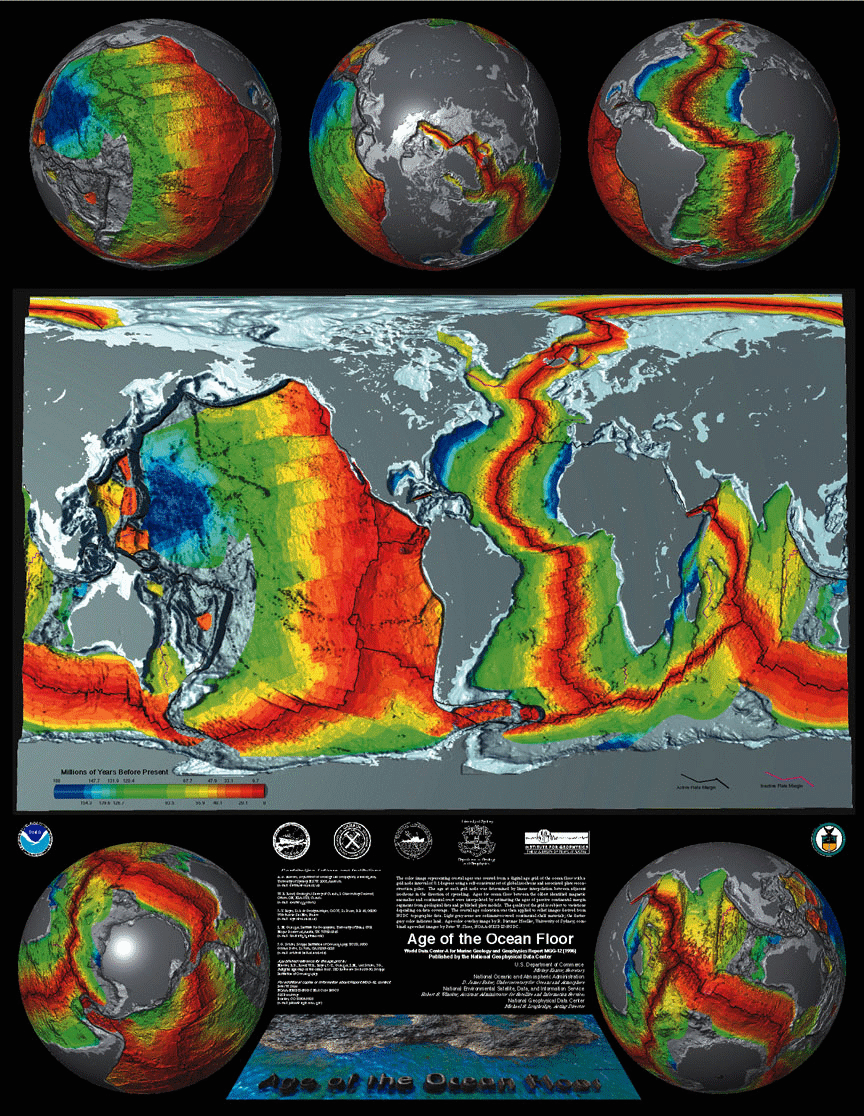
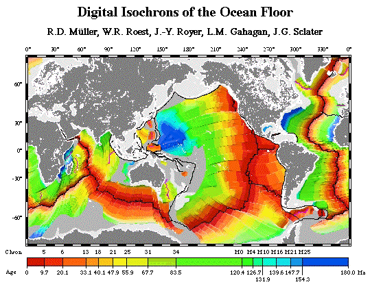
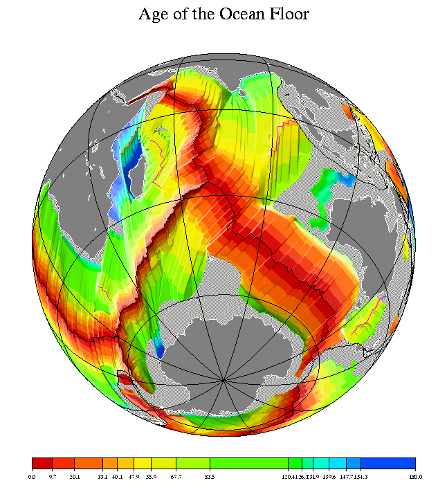
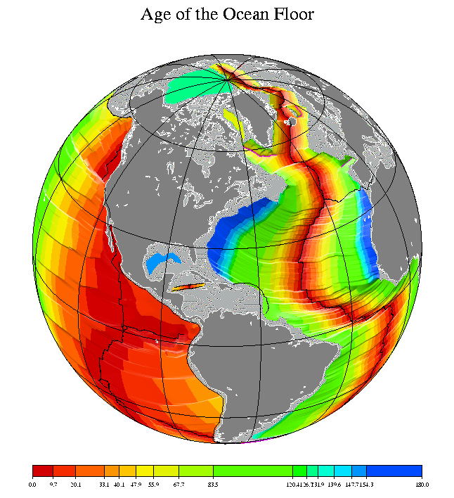
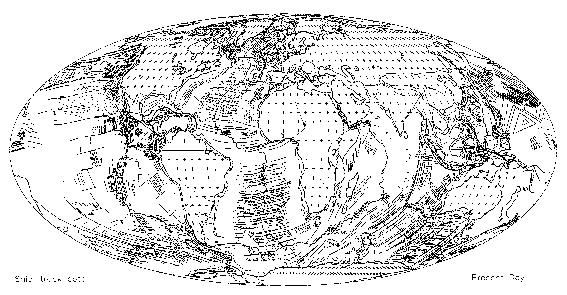
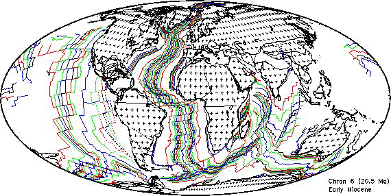
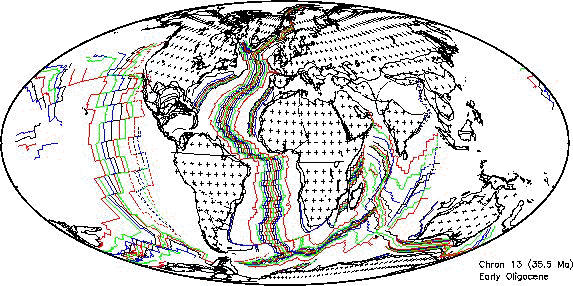
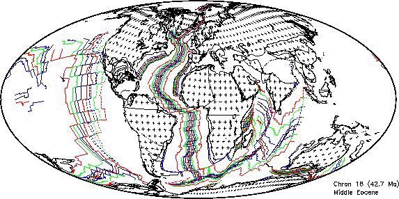
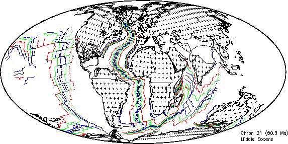
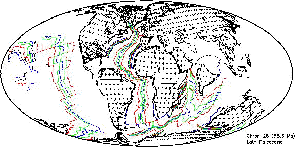
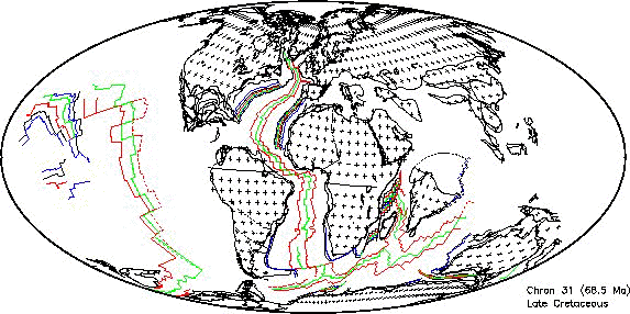
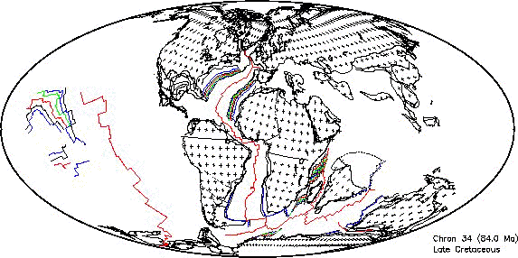
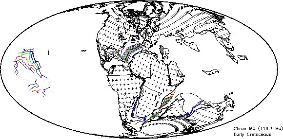
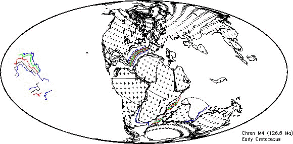
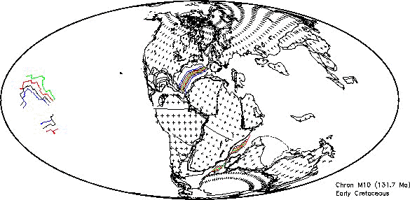
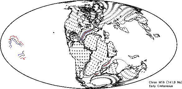
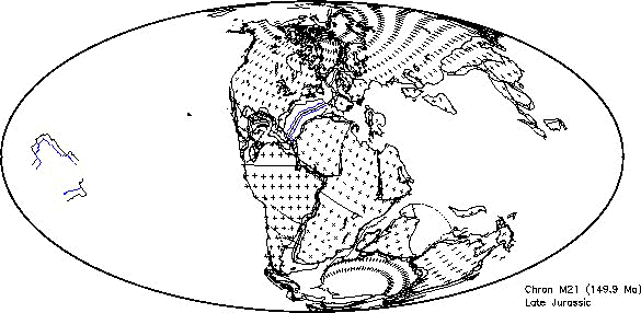
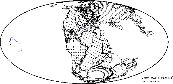
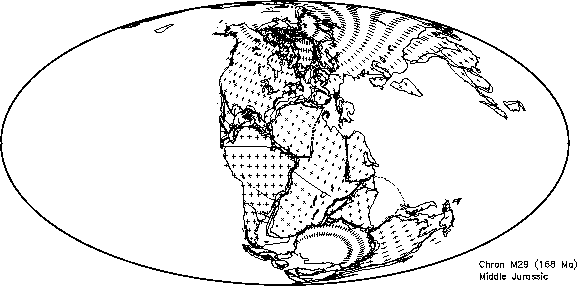
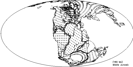