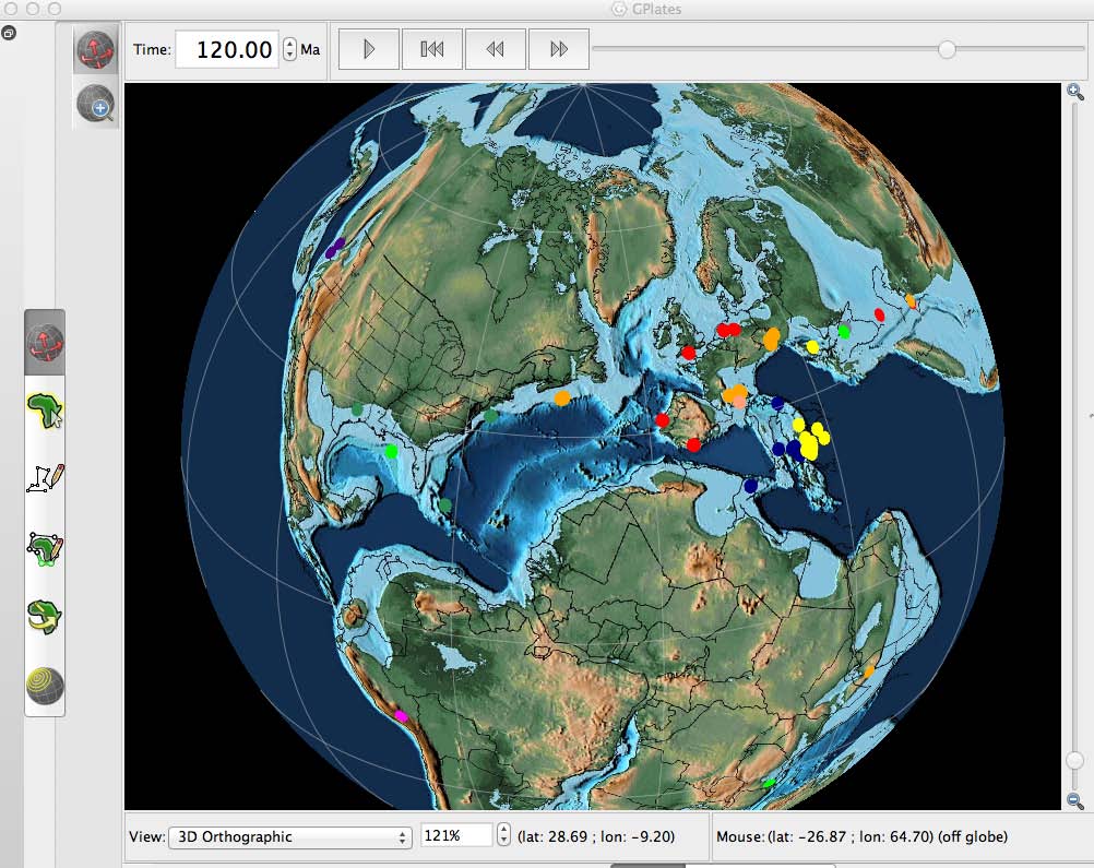
 The PALEOMAP PaleoAtlas for GPlates consists of 91 paleogeographic maps spanning the Phanerozoic and late Neoproterozoic. The PaleoAtlas can be directly loaded into GPlates as a Time Dependent Raster file. The paleogeographic maps in the PaleoAtlas illustrate the ancient configuration of the ocean basins and continents, as well as important topographic and bathymetric features such as mountains, lowlands, shallow sea, continental shelves, and deep oceans. This tutorial also describes how the maps in the PaleoAtlas were made, documents the sources of information used to make the paleogeographic maps, and provides instructions how to plot user-defined paleodata on the paleogeographic maps using the program PaleoDataPlotter. … Read more…
Data & Models

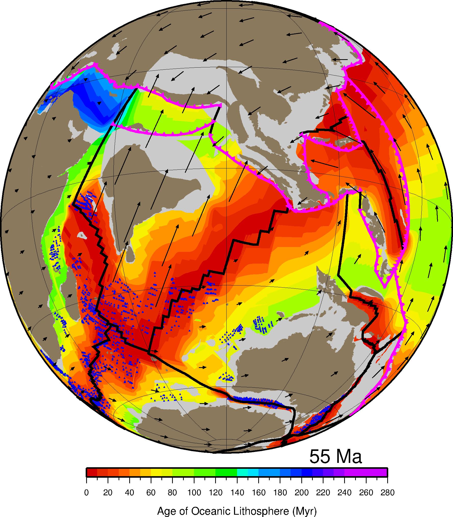
Ocean basin evolution and global-scale plate reorganization events since Pangea breakup
Citation
Müller R.D., Seton, M., Zahirovic, S., Williams, S.E., Matthews, K.J., Wright, N.M., Shephard, G.E., Maloney, K.T., Barnett-Moore, N., Hosseinpour, M., Bower, D.J., Cannon, J., 2016. Ocean basin evolution and global-scale plate reorganization events since Pangea breakup, Annual Review of Earth and Planetary Sciences, Vol 44, 107-138. DOI: 10.1146/annurev-earth-060115-012211.
Abstract
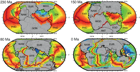
We present a revised global plate motion model with continuously closing plate boundaries ranging from the Triassic at 230 Ma to the present day, assess differences between alternative absolute plate motion models, and review global tectonic events. Relatively high mean absolute plate motion rates around 9–10 cm yr-1 between 140 and 120 Ma may be related to transient plate motion accelerations driven by the successive emplacement of a sequence of large igneous provinces during that time. … Read more…
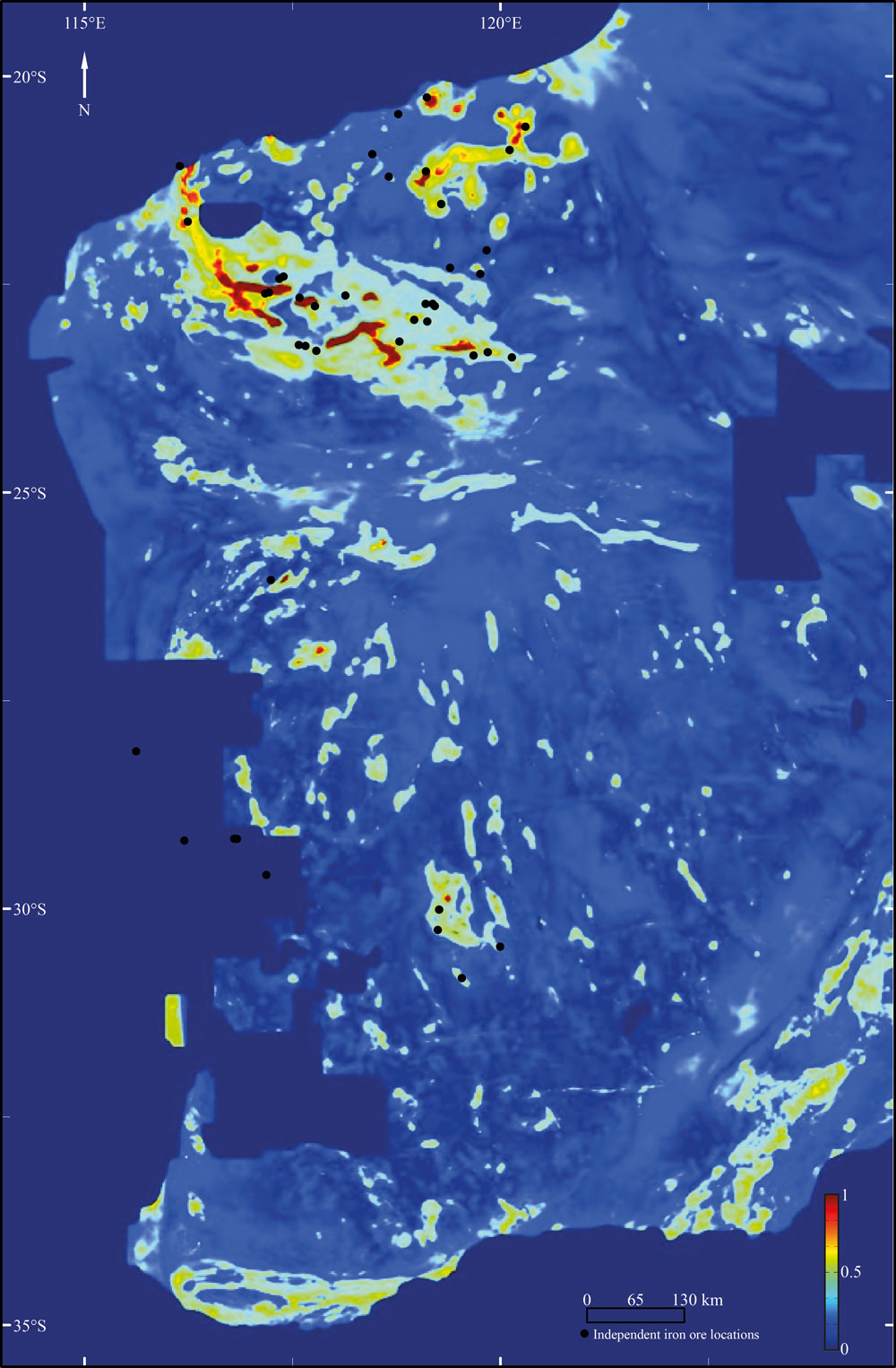
Prospectivity of Western Australian iron ore from geophysical data using a reject option classifier
Citation
Merdith, A. S., Landgrebe, T. C., & Müller, R. D. (2015). Prospectivity of Western Australian iron ore from geophysical data using a reject option classifier. Ore Geology Reviews. http://dx.doi.org/10.1016/j.oregeorev.2015.03.014
Abstract
There has recently been a rapid growth in the amount and quality of digital geological and geophysical data for the majority of the Australian continent. Coupled with an increase in computational power and the rising impor- tance of computational methods, there are new possibilities for a large scale, low expenditure digital exploration of mineral deposits. Here we use a multivariate analysis of geophysical datasets to develop a methodology that utilises machine learning algorithms to build and train two-class classifiers for provincial-scale, greenfield min- eral exploration. … Read more…
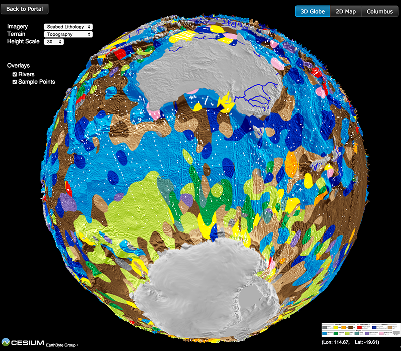
Seafloor lithology of the ocean basins
Citation
Dutkiewicz, A., Müller, R. D., O’Callaghan, S., & Jónasson, H. (2015). Census of seafloor sediments in the world’s ocean. Geology, G36883-1. doi: 10.1130/G36883.1.
Abstract
Knowing the patterns of distribution of sediments in the global ocean is critical for understanding biogeochemical cycles and how deep-sea deposits respond to environmental change at the sea surface. We present the first digital map of seafloor lithologies based on descriptions of nearly 14,500 samples from original cruise reports, interpolated using a support vector machine algorithm. We show that sediment distribution is more complex, with significant deviations from earlier hand-drawn maps, and that major lithologies occur in drastically different proportions globally. … Read more…
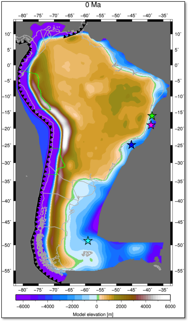
Influence of subduction history on South American topography
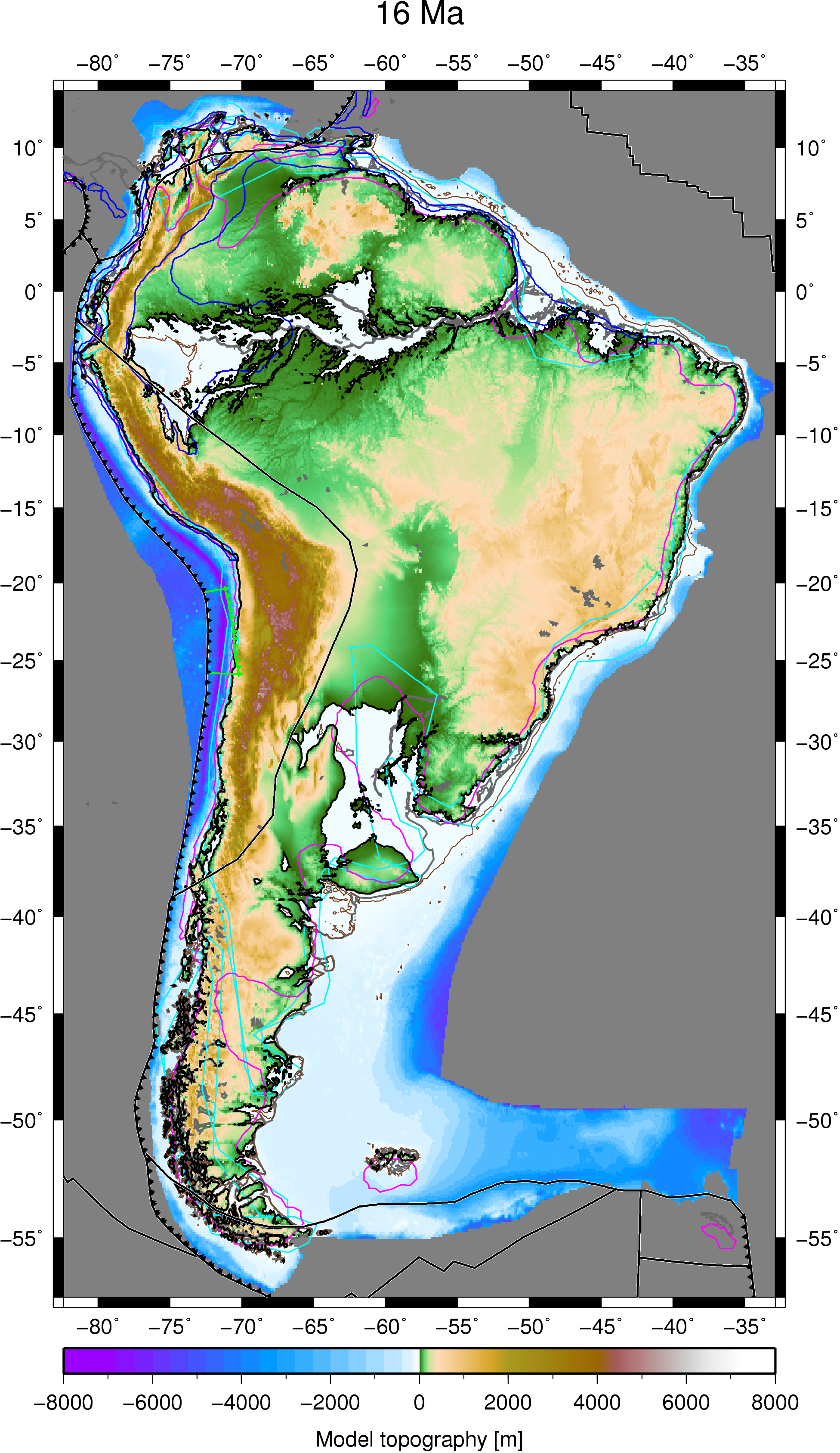 Citation
Flament, N., Gurnis, M., Müller, R. D., Bower, D. J., & Husson, L. (2015). Influence of subduction history on South American topography. Earth and Planetary Science Letters, 430, 9-18. doi: 10.1016/j.epsl.2015.08.006.
Abstract
The Cenozoic evolution of South American topography is marked by episodes of large-scale uplift and subsidence not readily explained by lithospheric deformation. The drying up of the inland Pebas system, the drainage reversal of the Amazon river, the uplift of the Sierras Pampeanas and the uplift of Patagonia have all been linked to the evolution of mantle flow since the Miocene in separate studies. Here we investigate the evolution of long-wavelength South American topography as a function of subduction history in a time-dependent global geodynamic model. This model is shown to be consistent with these inferred changes, as well as with the migration of the Chaco foreland basin depocentre, that we partly attribute to the inboard migration of subduction resulting from Andean mountain building. … Read more…
Geochemistry, Geophysics, Geosystems – Semi-automatic fracture zone tracking
Wessel, P., Matthews, K. J., Müller, R. D., Mazzoni, A., Whittaker, J. M., Myhill, R., & Chandler, M. T. (2015). Semi-automatic fracture zone tracking. Geochemistry, Geophysics, Geosystems. doi: 10.1002/2015GC005853. Semi-automatic fracture zone tracking This paper includes an update to the global seafloor tectonic fabric data set by Matthews et al. (JGR, 2011). Based on the vertical gravity … Read more…
Nature Geoscience – Long-term interaction between mid-ocean ridges and mantle plumes

Whittaker, J. M., Afonso, J. C., Masterton, S., Müller, R. D., Wessel, P., Williams, S. E., & Seton, M. (2015). Long-term interaction between mid-ocean ridges and mantle plumes. Nature Geoscience, 8(6), 479-483. doi: http://dx.doi.org/10.1038/ngeo2437. Summary Plate tectonic motions are commonly considered to be driven by slab pull at subduction zones and ridge push at mid-ocean … Read more…
Long-term interaction between mid-ocean ridges and mantle plumes
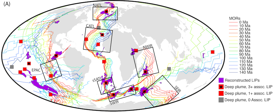 Citation
Whittaker, J. M., Afonso, J. C., Masterton, S., Müller, R. D., Wessel, P., Williams, S. E., & Seton, M. (2015). Long-term interaction between mid-ocean ridges and mantle plumes. Nature Geoscience, 8(6), 479-483.
Summary
Plate tectonic motions are commonly considered to be driven by slab pull at subduction zones and ridge push at mid-ocean ridges, with motion punctuated by plumes of hot material rising from the lower mantle. Within this model, the geometry and location of mid-ocean ridges are considered to be independent of lower-mantle dynamics, such as deeply sourced plumes that produce voluminous lava eruptions-termed large igneous provinces. Here we use a global plate model to reconstruct the locations of large igneous provinces relative to plumes and mid-ocean ridges at the time they formed. … Read more…
Evaluating global paleoshoreline models for the Cretaceous and Cenozoic
 Citation
Heine, C., Yeo, L. G., & Müller, R. D. (2015). Evaluating global paleoshoreline models for the Cretaceous and Cenozoic. Australian Journal of Earth Sciences, (ahead-of-print), 1-13., doi: 10.1080/08120099.2015.1018321.
Summary
Paleoshoreline maps represent the distribution of land and sea through geologic time. These compilations provide excellent proxies for evaluating the contributions non-tectonic vertical crustal motions, such as mantle convection-driven dynamic topography, to the flooding histories of continental platforms. Until now, such data have not been available as a globally coherent compilation. Here, we present and evaluate a set of Cretaceous and Cenozoic global shoreline data extracted from two independent published global paleogeographic atlases. … Read more…
A tectonic model reconciling evidence for the collisions between India, Eurasia and intra-oceanic arcs of the central-eastern Tethys
 Citation
Gibbons, A., Zahirovic, S., Muller, R.D., Whittaker, J., and Yatheesh, V. 2015. A tectonic model reconciling evidence for the collisions between India, Eurasia and intra-oceanic arcs of the central-eastern Tethys. Gondwana Research FOCUS, doi: 10.1016/j.gr.2015.01.001.
Summary
Despite several decades of investigations, inferences on the timing and nature of collisions along the Mesozoic–Cenozoic Eurasian margin remain controversial. We assimilate geological and geophysical evidence into a plate tectonic model for the India–Eurasia collision that includes continuously– … Read more…
Age, spreading rates and spreading asymmetry of the world’s ocean crust
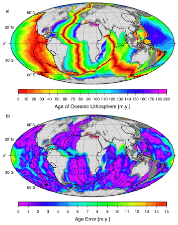
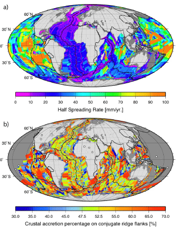 We present four companion digital models of the age, age uncertainty, spreading rates and spreading asymmetries of the world’s ocean basins as geographic and Mercator grids with 2 minute resolution. The grids include data from all the major ocean basins as well as detailed reconstructions of back-arc basins.
The age, spreading rate and asymmetry at each grid node is determined by linear interpolation between adjacent seafloor isochrons in the direction of spreading. Ages for ocean floor between the oldest identified magnetic anomalies and continental crust are interpolated by geological estimates of the ages of passive continental margin segments. … Read more…
Supplementary resources for "Absolute plate motions since 130 Ma constrained by subduction zone kinematics"
 Citation
Williams, S., Flament, N., Müller, R. D., & Butterworth, N. (2015). Absolute plate motions since 130 Ma constrained by subduction zone kinematics. Earth and Planetary Science Letters, 418, 66-77. doi:10.1016/j.epsl.2015.02.026.
Summary
The supplementary data set comprise plate reconstructions from 130 Ma to present-day, designed to be used within the open-source reconstruction software GPlates.
There are eight sets of reconstructions. In each case, the relative plate motion (RPM) model is unchanged; the differences lie in the absolute plate motion (APM) model. This is expressed in the rotation file as the finite poles of rotation that describe motion of Africa relative to the Earth’s spin-axis. These files were the basis of the results presented in the EPSL paper. … Read more…
Supplementary resources for “Absolute plate motions since 130 Ma constrained by subduction zone kinematics”
Citation
Williams, S., Flament, N., Müller, R. D., & Butterworth, N. (2015). Absolute plate motions since 130 Ma constrained by subduction zone kinematics. Earth and Planetary Science Letters, 418, 66-77. doi:10.1016/j.epsl.2015.02.026.
Summary
The supplementary data set comprise plate reconstructions from 130 Ma to present-day, designed to be used within the open-source reconstruction software GPlates.
There are eight sets of reconstructions. In each case, the relative plate motion (RPM) model is unchanged; the differences lie in the absolute plate motion (APM) model. This is expressed in the rotation file as the finite poles of rotation that describe motion of Africa relative to the Earth’s spin-axis. These files were the basis of the results presented in the EPSL paper. … Read more…
Linking rift propagation barriers to excess magmatism at volcanic rifted margins
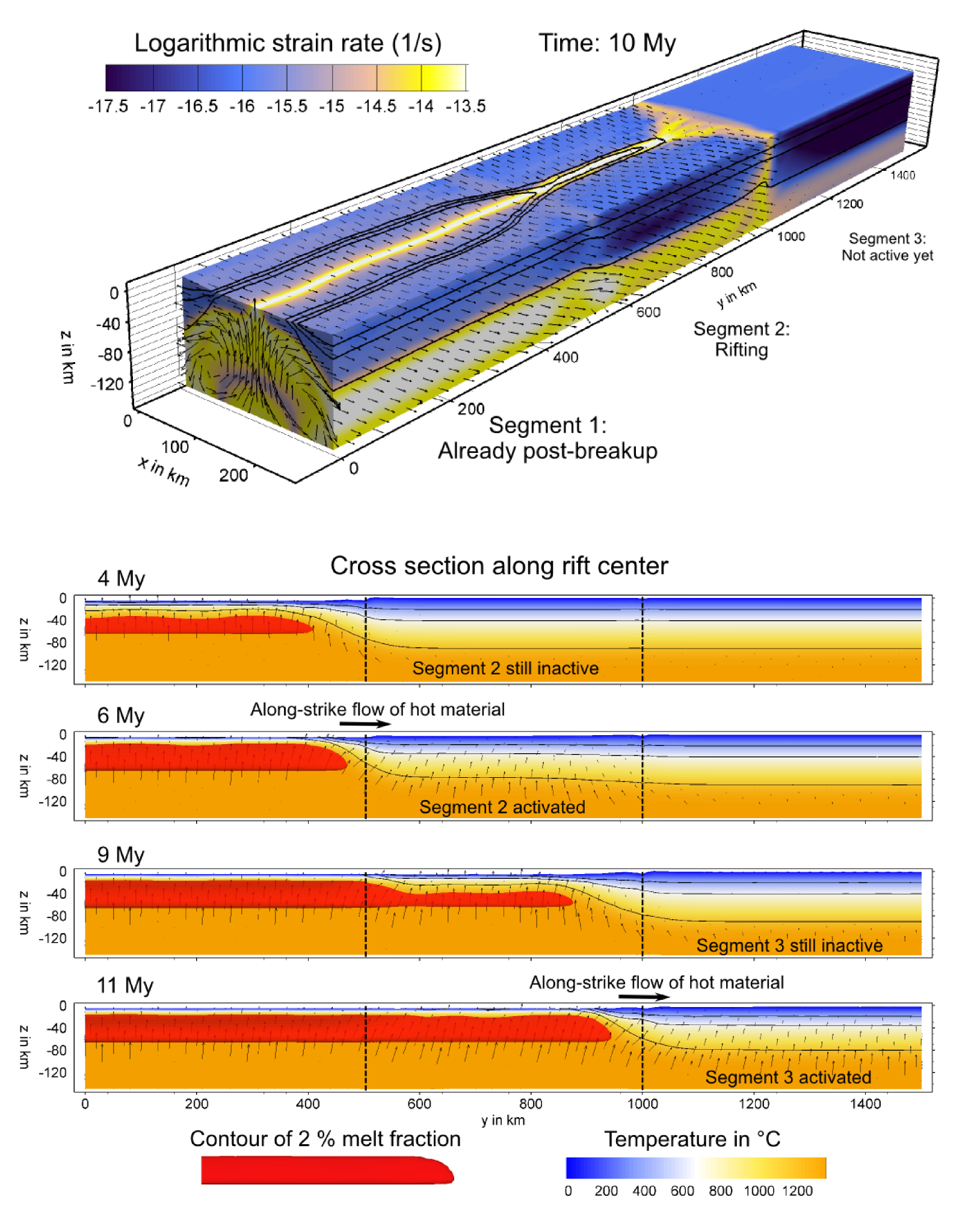 Citation
Koopman, H., Brune, S., Franke, D. and Breuer. 2014. Linking rift propagation barriers to excess magmatism at volcanic rifted margins. Geology (Pre-Issue Publication 15. Oct), doi: 10.1130/G36085.
Summary
Break-up–related extrusive magmatism, imaged in reflection seismic data as seaward-dipping reflectors (SDRs), extends sym- metrically along the volcanic margins of the Atlantic Ocean. Recent research found distinct along-margin variations in the distribution of SDRs, and abundance of volcanic material was found to be spatially linked to transfer fault systems. These segmented the propagating rift that later developed into the ocean, and are interpreted as rift propa- gation barriers. Based on these observations, we develop a numeri- cal model, which shows that rift-parallel mantle flow and locally enhanced rates of volcanism are the result of delays in rift propaga- tion and segmented opening. … Read more…
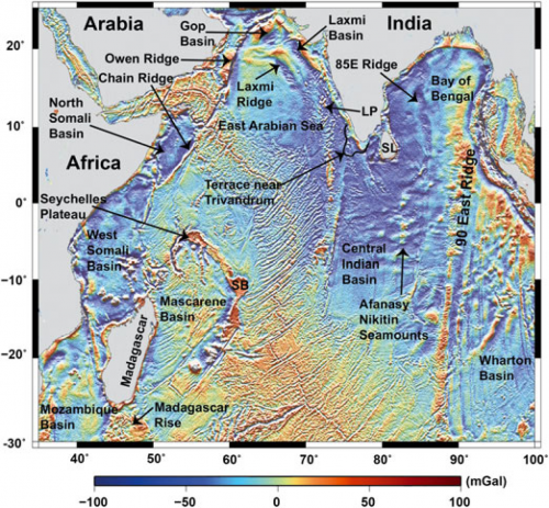
New global marine gravity model, Sandwell et al. (2014)
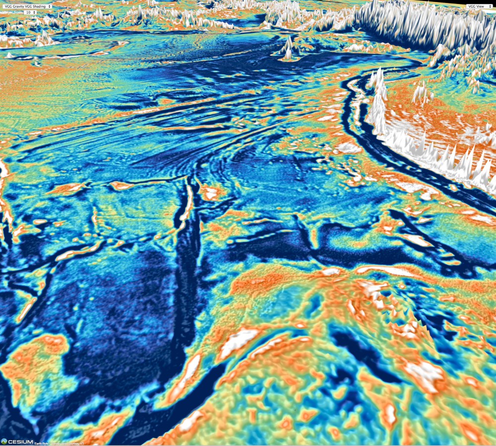 Citation
Sandwell, D. T., Müller, R. D., Smith, W. H. F., Garcia, E. and Francis, R. 2014. New global marine gravity model from Cryo-Sat-2 and jason-1 reveals buried tectonic structure. Science, Vol. 346, 6205, pp. 65-67, doi: 10.1126/science.1258213.
Summary
New global marine gravity model from CryoSat-2 and Jason-1 reveals buried tectonic structure.
View the new gravity map in an online 3D portal!
Gravity models are powerful tools for mapping tectonic structures, especially in the deep ocean basins where the topography remains unmapped by ships or is buried by thick sediment. We combined new radar altimeter measurements from satellites CryoSat-2 and Jason-1 with existing data to construct a global marine gravity model that is two times more accurate than previous models. We found an extinct spreading ridge in the Gulf of Mexico, a … Read more…
Post-Jurassic tectonic evolution of southeast Asia from Zahirovic et al. (2014)
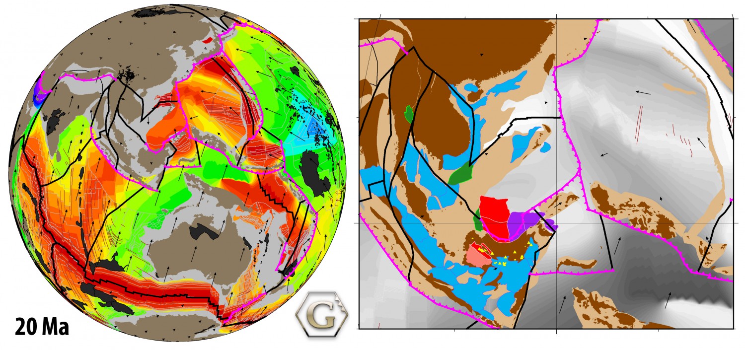 Citation
Zahirovic, S., Seton, M., and Müller, R. D., (2014). The Cretaceous and Cenozoic tectonic evolution of Southeast Asia: Solid Earth (EGU).
Summary
Tectonic reconstructions of Southeast Asia have given rise to numerous controversies that include the accretionary history of Sundaland and the enigmatic tectonic origin of the Proto South China Sea. We assimilate a diversity of geological and geophysical observations into a new regional plate model, coupled to a global model, to address these debates.
Our approach takes into account terrane suturing and accretion histories, the location of subducted slabs imaged in mantle tomography in order to constrain the evolution of regional subduction zones, as well as plausible absolute and relative plate velocities and tectonic driving mechanisms. … Read more…
The tectonic stress field evolution of India since the Oligocene
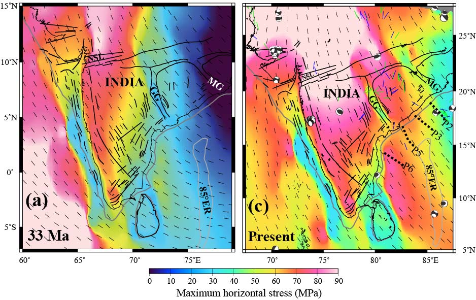 Citation
Müller, R. D., Yatheesh, V., & Shuhail, M. (2014). The tectonic stress field evolution of India since the Oligocene. Gondwana Research.
Summary
We use a 2 dimensional finite element model with heterogeneous elastic strengths in continental areas to model the regional stress field orientation and relative magnitudes in and around India for 33 Ma, 20 Ma and the present day. The large-scale geological structure of India is embedded in our model by using published outlines of cratons, fold belts and basins, associated with estimates of their relative strengths, enabling the modelling of stress field deflections along interfaces between relatively strong and weak tectonic elements through time. … Read more…
Geochemistry, Geophysics, Geosystems – Community infrastructure and repository for marine magnetic identifications
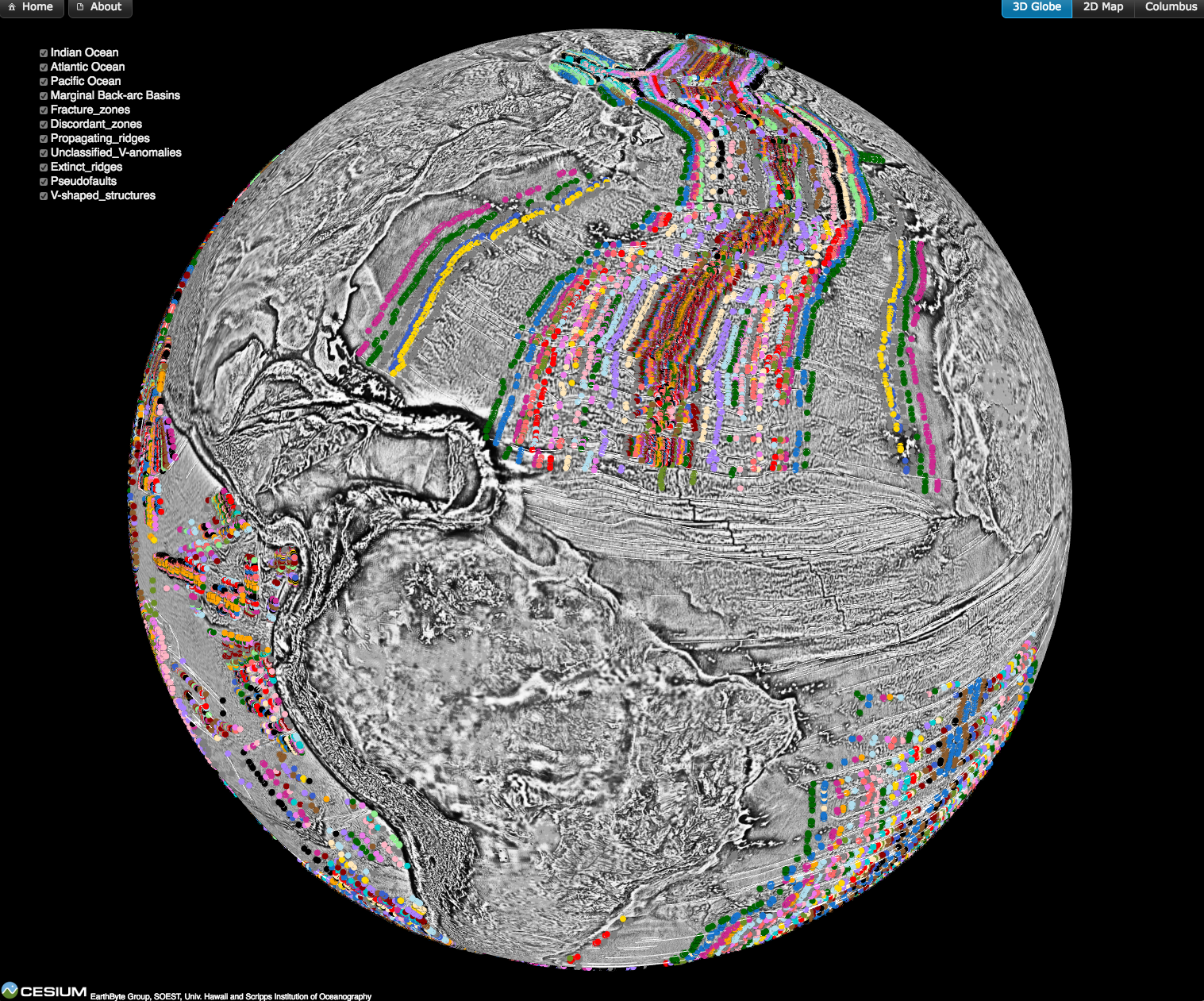 Magnetic anomaly identifications form the primary data set from which the age of the oceanic lithosphere can be determined, a critical component of reconstructing the seafloor spreading history of ocean basins. This data is now available as part of an open source, community-driven online repository that contains quality-checked magnetic anomaly picks, organised by ocean basin and publication source.
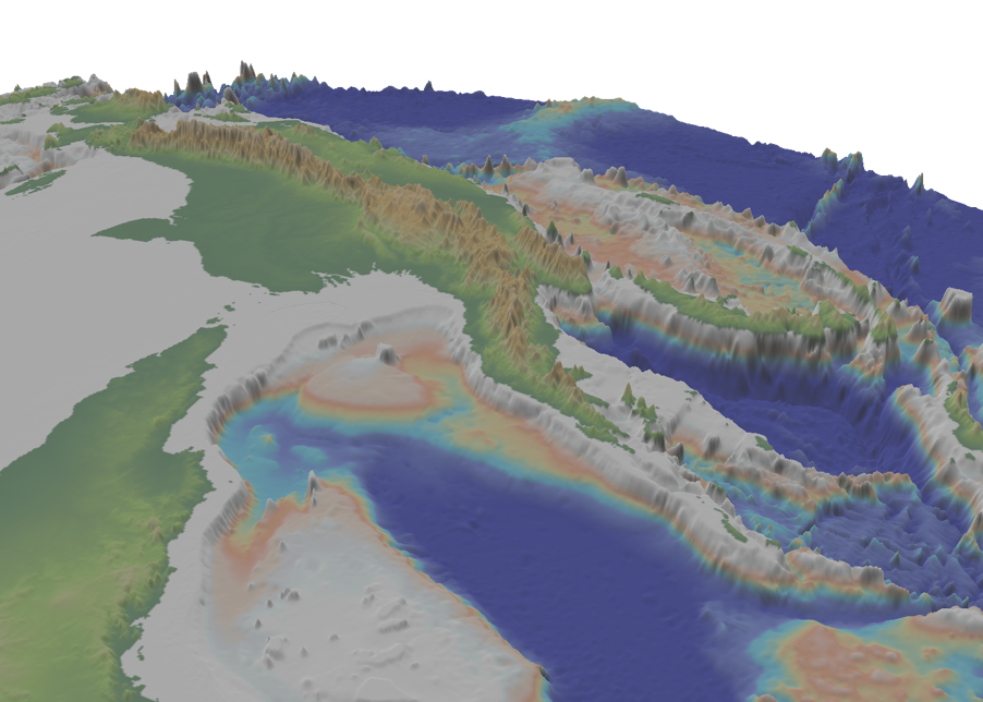
Topographic asymmetry of the South Atlantic from global models of mantle flow and lithospheric stretching
 Citation
Flament, N., Gurnis, M., Williams, S., Seton, M., Skogseid, J., Heine, C., & Müller, R. D. (2014). Topographic asymmetry of the South Atlantic from global models of mantle flow and lithospheric stretching. Earth and Planetary Science Letters, 387, 107-119. dx.doi.org/10.1016/j.epsl.2013.11.017.
Abstract
The relief of the South Atlantic is characterized by elevated passive continental margins along southern Africa and eastern Brazil, and by the bathymetric asymmetry of the southern oceanic basin where the western flank is much deeper than the eastern flank. We investigate the origin of these topographic features in the present and over time since the Jurassic with a model of global mantle flow and lithospheric deformation. The model progressively assimilates plate kinematics, plate boundaries and lithospheric age derived from global tectonic reconstructions with deforming plates, and predicts the evolution of mantle temperature, continental crustal thickness, long-wavelength dynamic topography, and isostatic topography. … Read more…
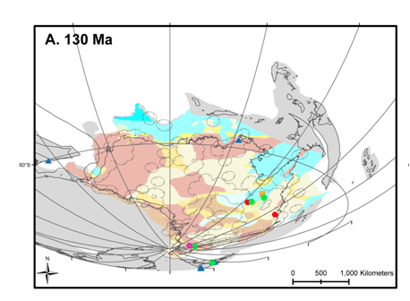
The breakup of east Gondwana: assimilating constraints from Cretaceous ocean basins around India into a best-fit tectonic model, Gibbons et al. (2013)
Citation
Gibbons, A., Whittaker, J. and R. Dietmar Müller, (2013), The break up of East Gondwana: assimilating constraints from Cretaceous ocean basins around India into a best-fit tectonic model. Journal of Geophysical Research, 118, 1-15: doi:10.1002/jgrb.50079
 Summary
Published models for the Cretaceous seafloor-spreading history of East Gondwana result in unlikely tectonic scenarios for at least one of the plate boundaries involved and/or violate particular constraints from at least one of the associated ocean basins. We link East Gondwana spreading corridors by integrating magnetic and gravity anomaly data from the Enderby Basin off East Antarctica within a regional plate kinematic framework to identify a conjugate series of east-west-trending magnetic anomalies, M4 to M0 (~126.7–120.4 Ma). … Read more…
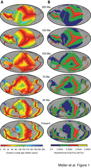
Seawater chemistry driven by supercontinent assembly, breakup and dispersal, Müller et al. (2013)
 Citation
Müller, R. D., Dutkiewicz, A., Seton, M. and Gaina, C. (2013). Seawater chemistry driven by supercontinent assembly, break-up and dispersal Geology. doi 10.1130/G34405.1.
Summary
Global oceans are known to have alternated between aragonite and calcite seas. These oscillations reflect changes in the Mg/Ca ratio of seawater, which control biomineralisation and the composition of marine carbonates and are thought to be caused by the time dependence of crustal accretion at mid-ocean ridge crests and associated high temperature mid-ocean ridge brine flux. Here we use global ocean basin reconstructions to demonstrate that these fluctuations are instead caused by the gradual growth and destruction of mid-ocean ridges and their relatively cool flanks during long-term tectonic cycles thus linking ocean chemistry to off-ridge low temperature hydrothermal flux. Early Jurassic aragonite seas were a consequence of supercontinent stability and minima in mid-ocean ridge length and basalt alteration. The break-up of Pangaea led to a gradual doubling in ridge length and a 50% increase in hydrothermal flux mainly through an enormous increase in ridge flank area, leading to enhanced alteration of basalt, lowered seawater Mg/Ca ratios and marine hypercalcification from 140 to 35 Ma. … Read more…
A review of observations and models of dynamic topography
Citation
Flament, N., Gurnis, M., & Müller, R. D. (2013). A review of observations and models of dynamic topography. Lithosphere, 5(2), 189-210. doi: 10.1130/L245.1
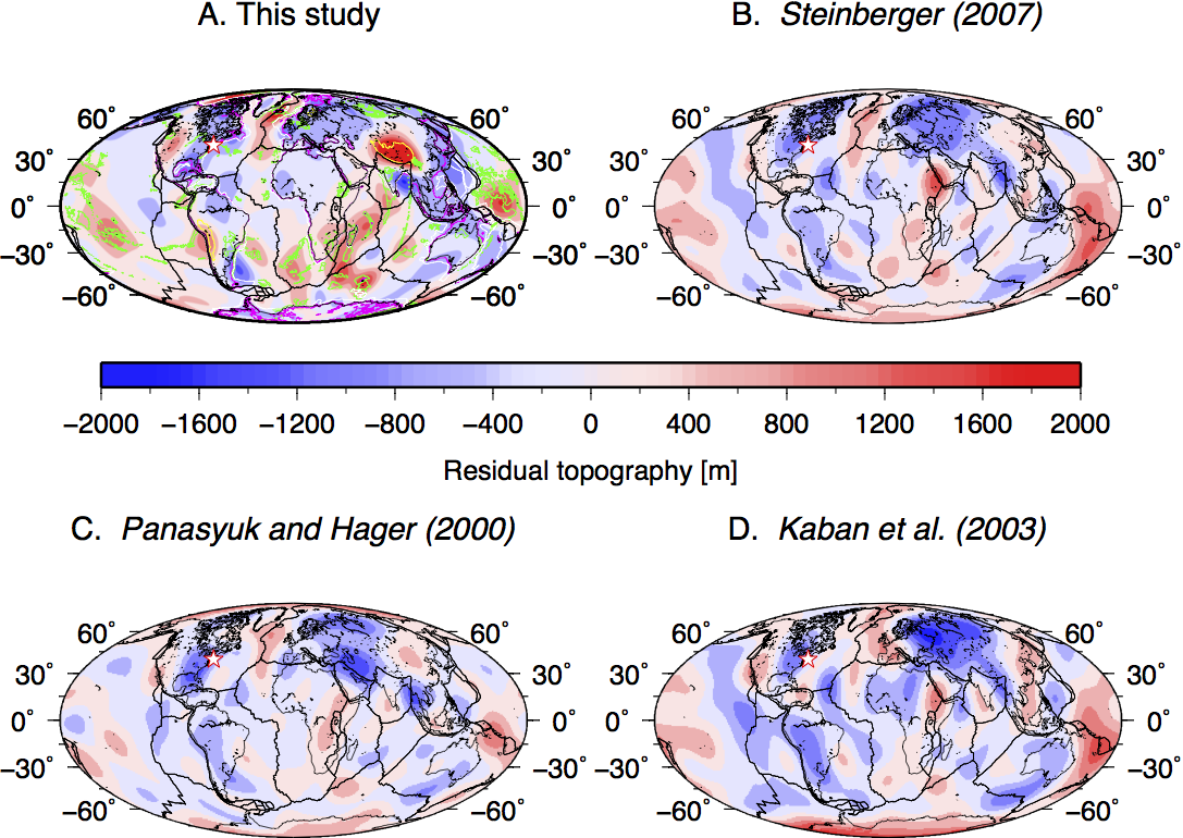 Summary
The topography of Earth is primarily controlled by lateral differences in the density structure of the crust and lithosphere. In addition to this isostatic topography, flow in the mantle induces deformation of its surface leading to dynamic topography. This transient deformation evolves over tens of millions of years, occurs at long wavelength, and is relatively small (<2 km) in amplitude. Here, we review the observational constraints and modeling approaches used to understand the amplitude, spatial pattern, and time dependence of dynamic topography. … Read more…
The tectonic evolution of the Arctic since Pangea breakup: Integrating constraints from surface geology and geophysics with mantle structure
![]() Citation
Citation
Shephard, G. E., Müller, R. D., & Seton, M. (2013). The tectonic evolution of the Arctic since Pangea breakup: Integrating constraints from surface geology and geophysics with mantle structure. Earth-Science Reviews, 124, 148-183. doi:10.1016/j.earscirev.2013.05.012
Summary
The tectonic evolution of the circum-Arctic, including the northern Pacific, Siberian and North American margins, since the Jurassic has been punctuated by the opening and closing of ocean basins, the accretion of autochthonous and allochthonous terranes and associated deformation. This complexity is expressed in the uncertainty of plate tectonic models of the region, with the time-dependent configurations and kinematic history remaining poorly understood. … Read more…
Total sediment thickness of the World’s Oceans & Marginal Seas, version 2
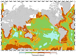 This update replaces the original Total Sediment Thickness of the World’s Oceans & Marginal Seas (Divins, 2003).
Citation
Whittaker, J. M., Goncharov, A., Williams, S. E., Müller, R. D., & Leitchenkov, G. (2013). Global sediment thickness data set updated for the Australian‐Antarctic Southern Ocean. Geochemistry, Geophysics, Geosystems, 14(8), 3297-3305. doi: 10.1002/ggge.20181.
Summary
NGDC’s global ocean sediment thickness grid (Divins, 2003) has been updated for the Australian-Antarctic region (60°-155°E, 30°-70°S). New seismic reflection and refraction data have been used to add detail to the conjugate Australian and Antarctic margins and intervening ocean floor where previously regional sediment thickness patterns were poorly known. … Read more…
Towards community-driven paleogeographic reconstructions: integrating open-access paleogeographic and paleobiology data with plate tectonics
 Summary
A variety of paleogeographic reconstructions have been published, with applications ranging from paleoclimate, ocean circulation and faunal radiation models to resource exploration; yet their uncertainties remain difficult to assess as they are generally presented as low-resolution static maps. We present a methodology for ground-truthing the digital Palaeogeographic Atlas of Australia by linking the GPlates plate reconstruction tool to the global Paleobiology Database and a Phanerozoic plate motion model.
We develop a spatio-temporal data mining workflow to validate the Phanerozoic Palaeogeographic Atlas of Australia with paleoenvironments derived from fossil data. … Read more…
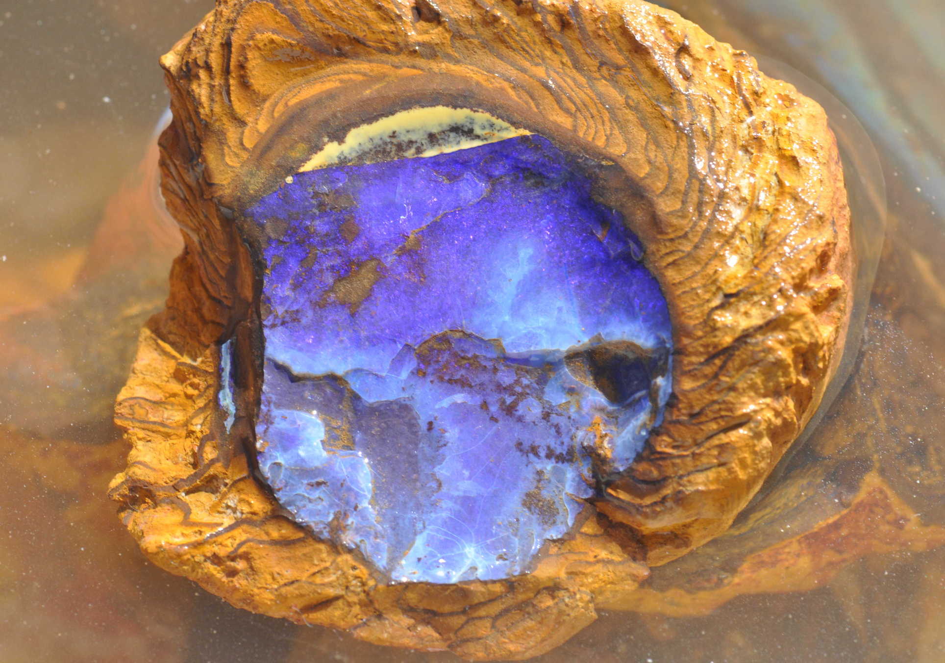
From data mining to opal mining
 Documents
AJES Paper
CG Paper
Opal is Australia’s national gemstone, however most significant opal discoveries were made in the early 1900’s – more than 100 years ago – until recently. Currently there is no formal exploration model for opal, meaning there are no widely accepted concepts or methodologies available to suggest where new opal fields may be found. … Read more…
Global continental and ocean basin reconstructions since 200 Ma
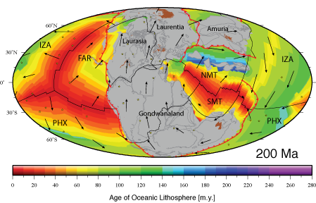 Global plate motion models provide a spatial and temporal framework for geological data and have been effective tools for exploring processes occurring at the earth’s surface. However, published models either have insufficient temporal coverage or fail to treat tectonic plates in a self-consistent manner. They usually consider the motions of selected features attached to tectonic plates, such as continents, but generally do not explicitly account for the continuous evolution of plate boundaries through time. … Read more…
Australian Paleo-stress map project
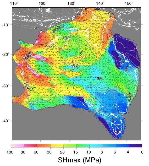 Using the engineering finite element modelling software package ABAQUS we have modelled the horizontal compressive stress of the Indo-Australian plate for time periods dating from the mid-Cretaceous. This work was carried out as part of the Tectonic Reactivation and Palaeo-Stress (TRAPS) Linkage project in collaboration with Shell, BHP Billiton,Woodside Petroleum and SANTOS in order to create a framework for predicting the tectonic reactivation of faults through time.
Download
Download dataset – zip file … Read more…
The IntraCONtinental basinS (ICONS) atlas
The ICONS atlas is a collection of basin data for over 240 intracontinental sedimentary basins, displaying crustal structure data, computed extension factors and tectonic subsidence grids and derivatives thereof as well as the dynamic topography evolution of a given basin. The atlas was compiled by Christian Heine as part of his PhD project investigating the formation and … Read more…
Testing absolute plate reference frames and the implications for the generation of geodynamic mantle heterogeneity structure
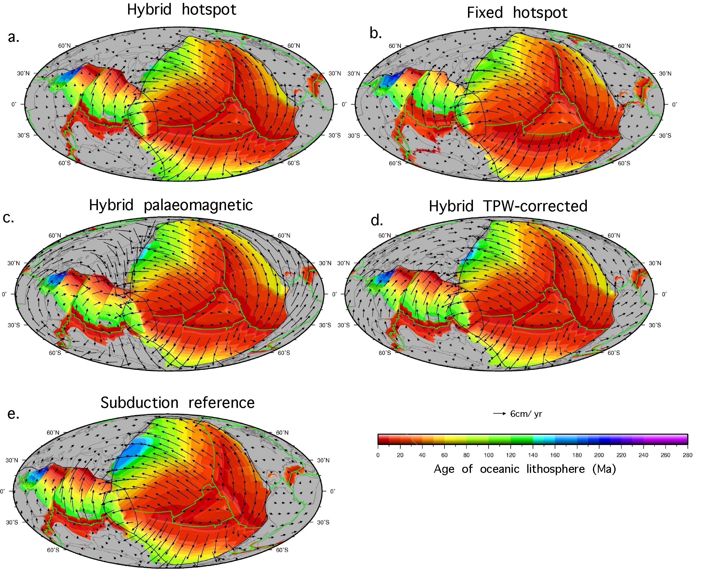 Absolute reference frames are a means of describing the motion of plates on the surface of the Earth over time, relative to a fixed point or frame. Multiple models of absolute plate motion have been proposed for the Cretaceous-Tertiary period, however, estimating the robustness and limitations of each model remains a significant limitation for refining both regional and global models of plate motion as well as fully integrated and time dependent geodynamic models. Here, we use a novel approach to compare five models of absolute plate motion in terms of their consequences for forward modelled deep mantle structure since at least 140 Ma. … Read more…