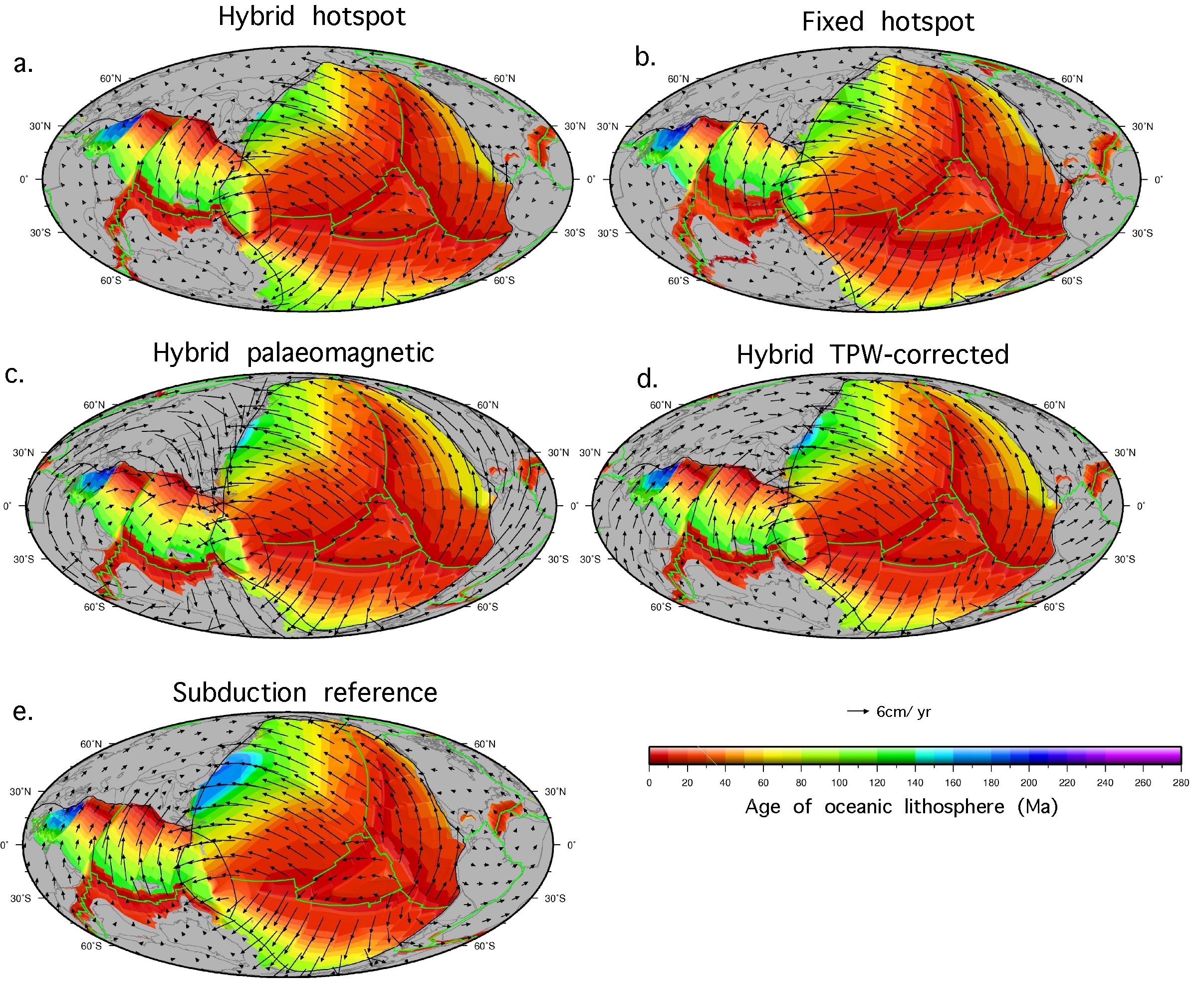
 Absolute reference frames are a means of describing the motion of plates on the surface of the Earth over time, relative to a fixed point or frame. Multiple models of absolute plate motion have been proposed for the Cretaceous-Tertiary period, however, estimating the robustness and limitations of each model remains a significant limitation for refining both regional and global models of plate motion as well as fully integrated and time dependent geodynamic models. Here, we use a novel approach to compare five models of absolute plate motion in terms of their consequences for forward modelled deep mantle structure since at least 140 Ma. … Read more…
Resources
EarthByte endeavours to make a variety of geological and geophysical data sets available to the community with every publication and project collaboration.
Where possible, all our data sets are able to be visualised using GPlates. Furthermore, every GPlates release is accompanied by a sample data bundle which includes published reconstruct-able raster and vector data.
Our data sets are available below, and are attached to their publication or news item. When using these data please cite the relevant publication.
| Software and Workflows |
|---|
| Badlands |
| Bayeslands |
| GPlates |
| pyGPlates |
| Underworld |
| PyBacktrack |

Dynamic topography and anomalously negative residual depth of the Argentine Basin
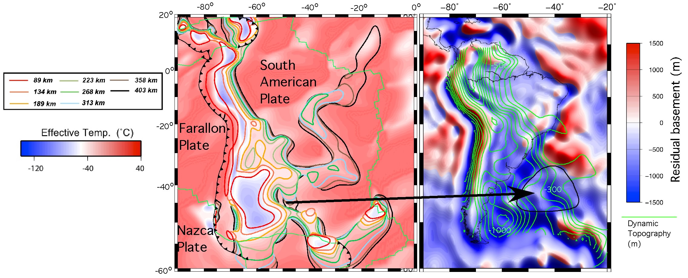 A substantial portion of Earth’s topography is known to be caused by the viscous coupling of mantle flow to the lithosphere but the relative contributions of shallow asthenospheric flow versus deeper flow remains controversial. The Argentine Basin, located offshore of the Atlantic margin of southern South America, is one of the most anomalously deep ocean regions as it is significantly deeper than its age would suggest. … Read more…
Constraining the Jurassic extent of Greater India: Tectonic evolution of the West Australian margin
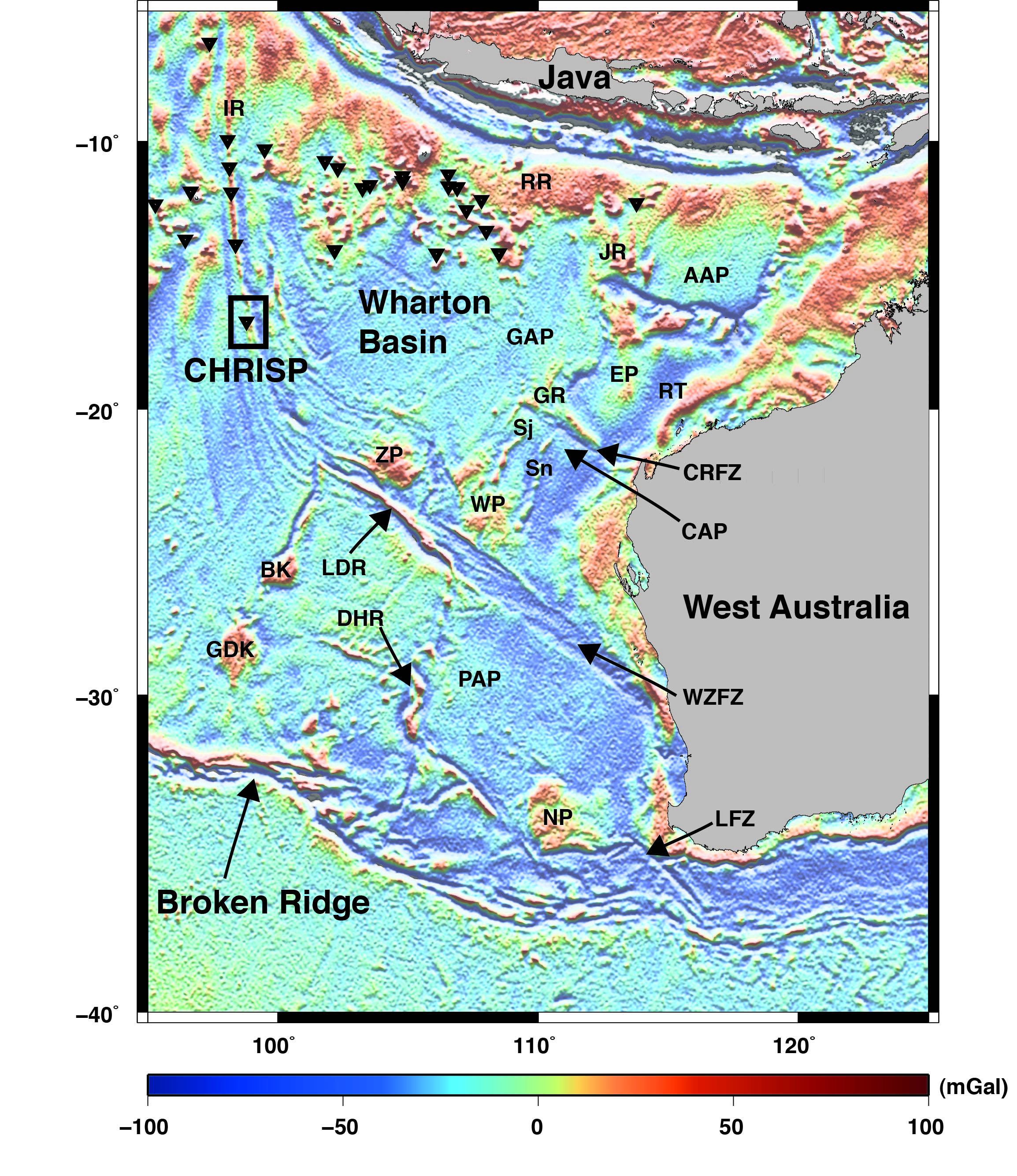 We present the Indian Ocean plate tectonic model accompanying the study of Gibbons et al., (2012). This work details the first regional-scale tectonic model of the breakup of East Gondwana. Our model shows that the breakup of East Gondwana started with the migration of a continental sliver, Argoland, in the Late Jurassic and was followed by breakup between Greater India and Australia-Antarctica in the Early Cretaceous, involving spreading reconfigurations, which left several sunken continental plateaus of Indian crust on the Australian plate. New evidence from seafloor off northwest Australia also shows that the majority of Greater India reached only about halfway up the West Australian margin, to the Wallaby-Zenith Plateaus. … Read more…
An open-source software environment for visualizing and refining plate tectonic reconstructions using high-resolution geological and geophysical data sets
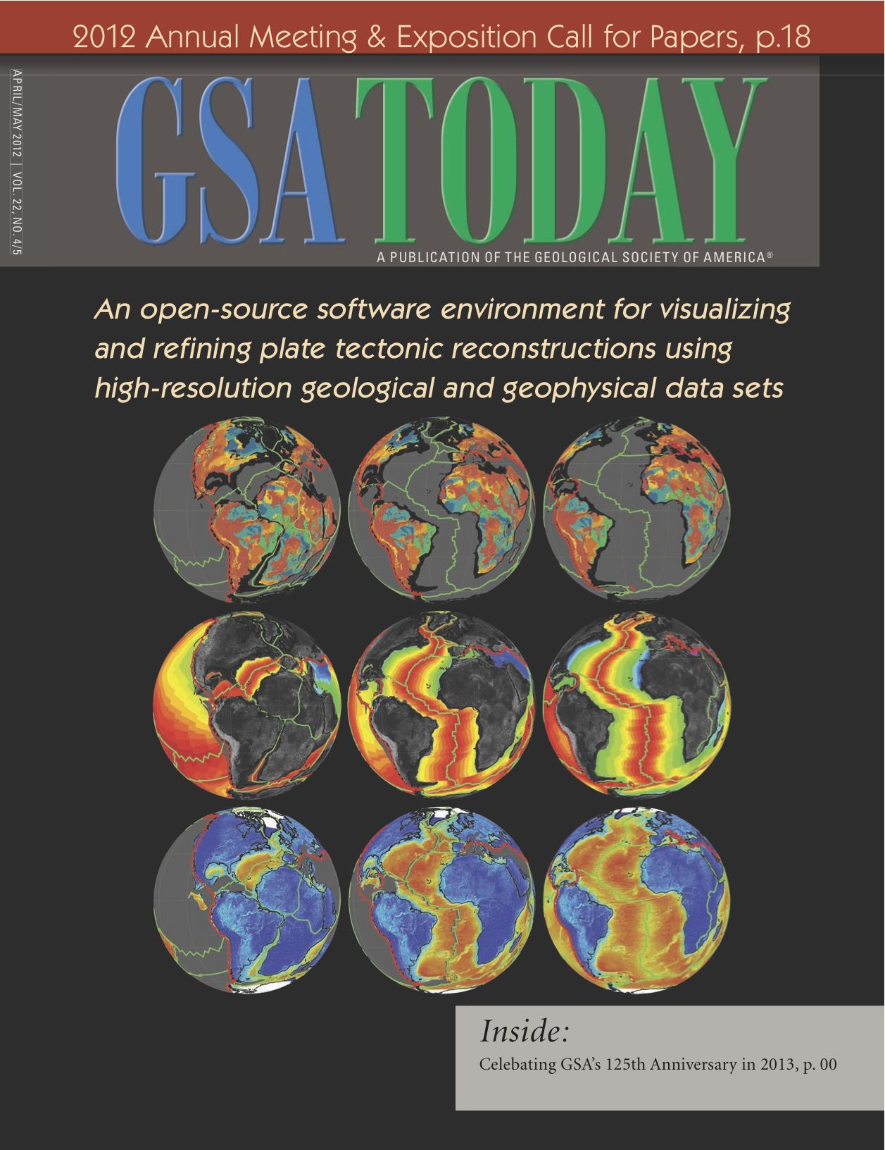 We describe a powerful method to explore spatio-temporal relationships within geological and geophysical data sets by analyzing the data within the context of tectonic reconstructions. GPlates is part of a new generation of plate reconstruction software that incorporates functionality familiar from GIS software with the added dimension of geological time. Here we use GPlates to reconstruct geological terranes, geophysical grids, and paleomagnetic data within alternative tectonic models of the assembly of Western Australia and the configuration of Rodinia. With the ability to rapidly visualize a diverse range of geological and geophysical constraints within different reconstructions, users can easily investigate the implications of different tectonic models for reconciling a variety of observations and make more informed choices between different models and data. … Read more…
Insights on the kinematics of the India-Eurasia collision from global geodynamic models
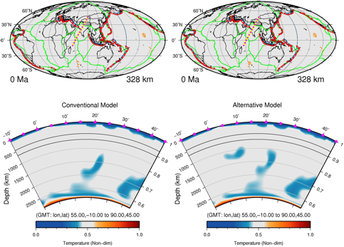 We present the input plate motion models and results from the study by Zahirovic et al. (2012) on the India-Eurasia collision using linked kinematic and geodynamic models.
Two end-member scenarios of the India-Eurasia collision were tested. The conventional model invokes long-lived Andean-style subduction along southern Eurasia until continental collision between a maximum extent Greater India and Lhasa at ~60 Ma. … Read more…
The tectonic fabric of the ocean basins
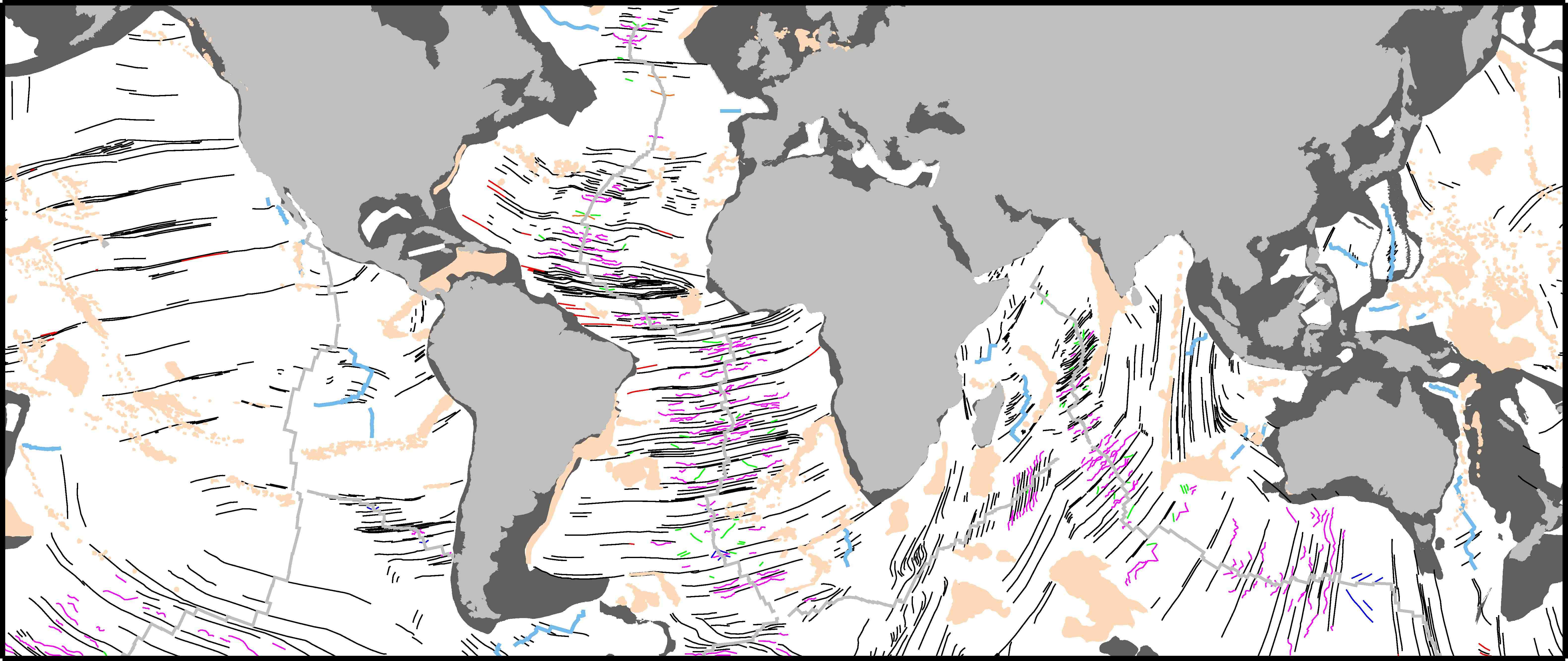 We present a global community data set of fracture zones (FZs), discordant zones, propagating ridges, V-shaped structures and extinct ridges, digitized from vertical gravity gradient (VGG) maps.
… Read more…
GPlates 1.0 now available to download
GPlates 1.0 has been released! Click here to download the latest version of GPlates
Full-fit, palinspastic reconstruction of the conjugate Australian-Antarctic margins
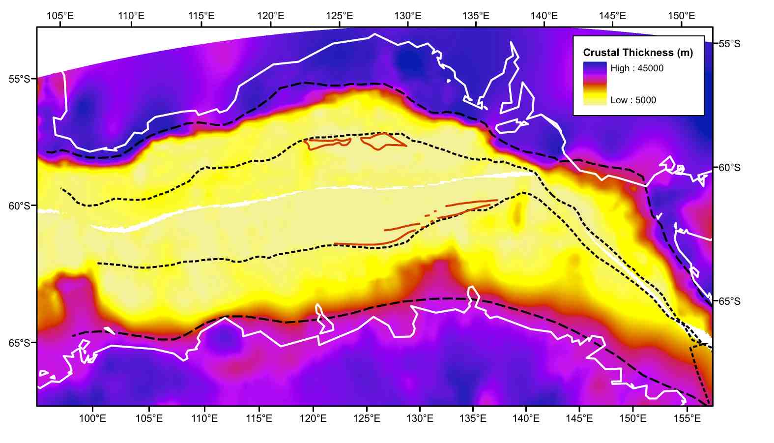 Despite decades of study the pre-rift configuration and early rifting history between Australia and Antarctica is not well established. The plate boundary system during the Cretaceous includes the evolving Kerguelen-Broken Ridge Large Igneous Province in the west as well as the conjugate passive and transform margin segments of the Australian and Antarctic continents. … Read more…
Dynamic subsidence of eastern Australia during the Cretaceous
![]() During the Early Cretaceous Australia’s eastward passage over sinking subducted slabs induced widespread dynamic subsidence and formation of a large eperiogenic sea in the eastern interior. Despite evidence for convergence between Australia and the paleo-Pacific, the subduction zone location has been poorly constrained. Using coupled plate tectonic-mantle convection models, we test two end-member scenarios, one with subduction directly east of Australia’s reconstructed continental margin, and a second with subduction translated ~1000 km east, implying the existence of a back-arc basin. Our models incorporate a rheological model for the mantle and lithosphere, plate motions since 140 Ma and evolving plate boundaries. While mantle rheology affects the magnitude of surface vertical motions, timing of uplift and subsidence depends on plate boundary geometries and kinematics. … Read more…
During the Early Cretaceous Australia’s eastward passage over sinking subducted slabs induced widespread dynamic subsidence and formation of a large eperiogenic sea in the eastern interior. Despite evidence for convergence between Australia and the paleo-Pacific, the subduction zone location has been poorly constrained. Using coupled plate tectonic-mantle convection models, we test two end-member scenarios, one with subduction directly east of Australia’s reconstructed continental margin, and a second with subduction translated ~1000 km east, implying the existence of a back-arc basin. Our models incorporate a rheological model for the mantle and lithosphere, plate motions since 140 Ma and evolving plate boundaries. While mantle rheology affects the magnitude of surface vertical motions, timing of uplift and subsidence depends on plate boundary geometries and kinematics. … Read more…
GPlates 0.9.10 now available to download
GPlates 0.9.10 has been released! See the new GPlates demo video for all the latest features. Watch the GPlates 0.9.10 introduction video here
How supercontinents and superoceans affect seafloor roughness
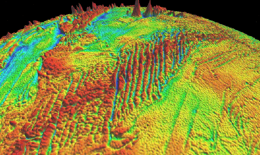
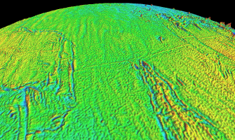
Seafloor roughness varies considerably across the world’s ocean basins and is fundamental to controlling the circulation and mixing of heat in the ocean and dissipating eddy kinetic energy. Models derived from analyses of active mid-ocean ridges suggest that ocean floor roughness depends on seafloor spreading rates, with rougher basement forming below a half-spreading rate threshold of 30-35 mm/yr, as well as on the local interaction of mid-ocean ridges with mantle plumes or cold-spots.
… Read more…
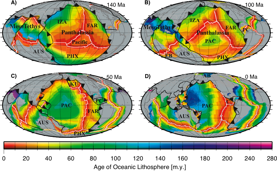
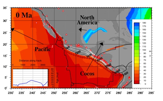
Age and Bathymetry of the World’s Ocean Crust for the last 140 million years
 Reconstructing vanished oceans
We establish the locations and geometry of mid ocean ridges through time on the basis of marine magnetic anomaly identifications, geological information such as paleomagnetic data from terranes and microcontinents, especially in the Tethys Ocean, mid-oceanic ridge subduction events and the rules of plate tectonics. Based on a global set of tectonic plate rotations we construct a set of refined seafloor isochrons following the interpolation technique outlined by Müller et al. (1997; 2008) but including a multitude of additional data. … Read more…
Herold et al. 2008 Mid Miocene topographic/bathymetric dataset
Citation: Herold, N., Seton, M., Muller, R.D., You, Y. and Huber, M. (2008). Middle Miocene tectonic boundary conditions for use in climate models. Geochemisty Geophysics Geosystems, 9, Q10009. doi:10.1029/2008GC002046. Abstract: Utilizing general circulation models (GCMs) for paleoclimate study requires the construction of appropriate model boundary conditions. We present a middle Miocene paleotopographic and paleobathymetric reconstruction … Read more…
Global subduction and back-arc basin grids and data
Please Note: These age grids are now outdated. Please see the agegrids available from the Müller et al. 2013 study on Ocean Chemistry at the Seawater chemistry driven by supercontinent assembly, break-up and dispersal resource page.
 Downloads
Download global subduction age grid images via FTP here – tgz file
Download global subduction parameter dataset via FTP here – tgz file
… Read more…
Ellipsis
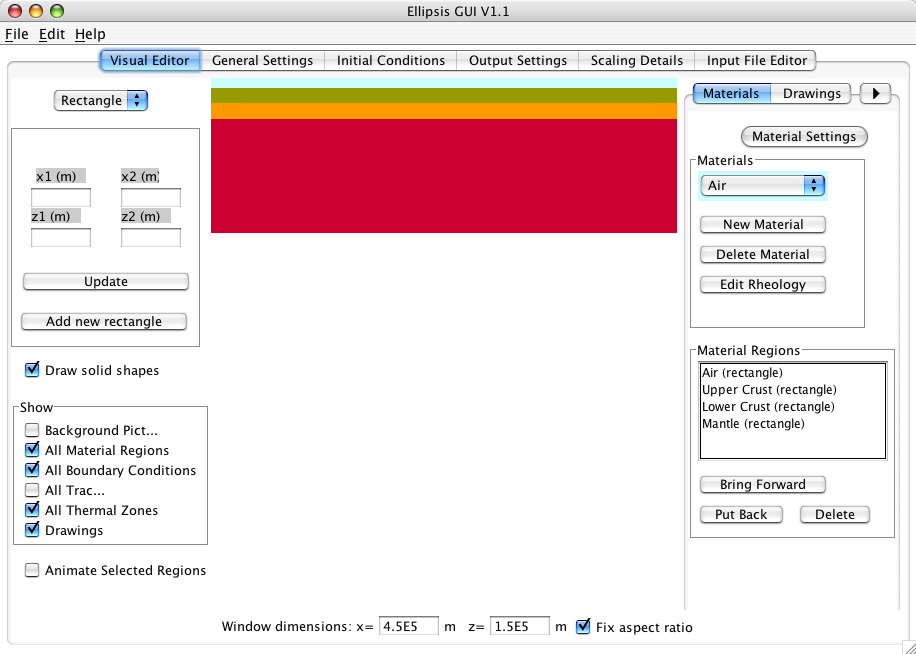 Ellipsis is a lagrangian particle-in-cell finite element modelling software tool with an associated graphical user interface (GUI). Ellipsis, along with its GUI and its associated documentation allow novice users to assemble 2D or 3D numerical experiment for lithospheric extension and/or compression over a convecting mantle or simply run a mantle convection experiment with or without continents in a relatively short time, including the scaling of relevant parameters. … Read more…
Underworld
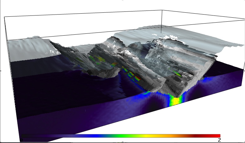 Underworld is a StGermain parallel modelling framework Geoscience research code, which utilises a Lagrangian particle-in-cell finite element scheme (the prototype of which is the Ellipsis code), visualised using gLucifer.
Generic Mapping Tools (GMT)
GMT is an open source collection of about 80 command-line tools for manipulating geographic and Cartesian data sets (including filtering, trend fitting, gridding, projecting, etc.) and producing PostScript illustrations ranging from simple x–y plots via contour maps to artificially illuminated surfaces and 3D perspective views; the GMT supplements add another 40 more specialized and discipline-specific … Read more…
Plate Boundaries
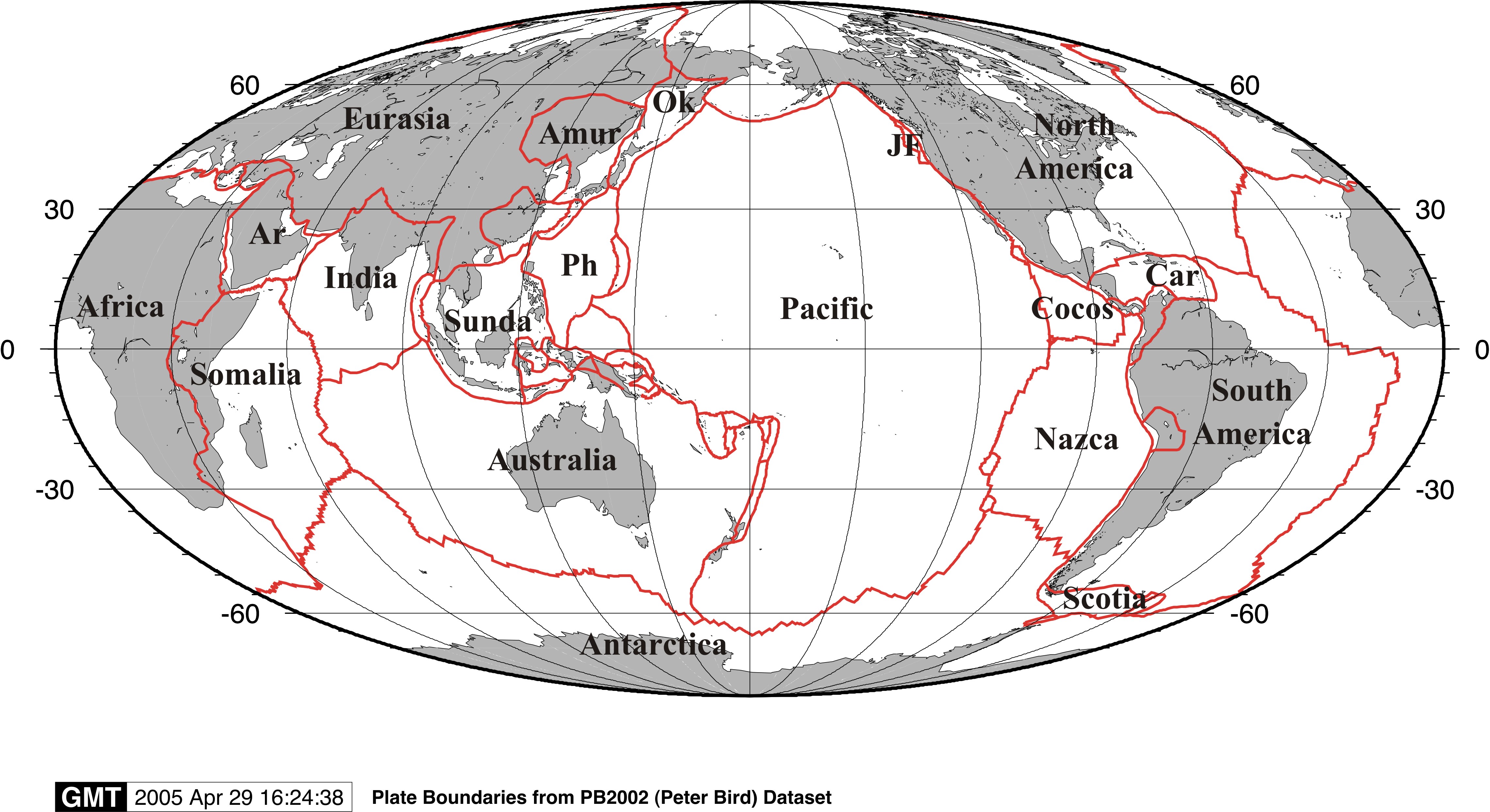 Mollweide projection of the Peter Bird (2003) plate boundary dataset. … Read more…