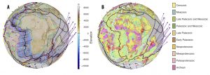
A paper about the GPlates software has been published in G-cubed. The GPlates virtual globe software provides the capability to reconstruct geodata attached to tectonic plates to develop and modify models that describe how the plates and their boundaries have evolved through time. It allows users to deform plates and to visualize surface tectonics in the context of convecting mantle structure and evolution by importing seismic tomography models or outputs from geodynamic models. GPlates applications include tectonics, geodynamics, basin evolution, orogenesis, deep Earth resource exploration, paleobiology, paleoceanography, and paleoclimate. The software is enabling end‐users in universities, government organizations, industry, and schools to explore the evolution of planet Earth on their desktop. Download GPlates here: http://www.gplates.org/ and stay tuned for the upcoming release of GPlates2.1.
Link to the paper.
![]()

