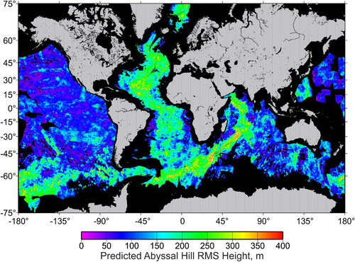
The dependence of abyssal hill roughness on mid-ocean ridge (MOR) spreading rate is an important indicator for faulting and volcanism. I reanalyze this relationship using a global gravity-based prediction of root-mean-square (RMS) heights, enabling dense sampling of RMS/spreading rate space and thus a far more detailed examination than possible with bathymetric data. RMS histograms are multimodal, indicating previously unrecognized complexity in roughness versus spreading rate that cannot be characterized by a single trend. Modal peaks are used to define four different types of abyssal hills, three of which can be associated with axial valley, transitional, and axial high MOR morphology. The most abundant type at any one spreading rate bin is used to define a “characteristic” trend that transitions abruptly from axial valley to axial high types across half rates of ~20 to 30 mm/yr. Abyssal hills outside this trend are associated geographically with anomalously “hot” and “cold” mantle regions.
Though covered by the oceans, abyssal hills are the most common landform on Earth. They form at the world’s spreading centers and are important records of the plate spreading process. Here I investigate the global relationship between spreading rates and abyssal hill heights using a new map of predicted heights based on satellite gravity data. This provides a far more complete picture of the relationship compared with earlier efforts using only sonar bathymetry data—one that is far more complex and requires multiple functional relationships. I identify four different “types” of abyssal hills based on this analysis, three of which can be correlated with different fundamental types of mid-ocean ridge spreading centers (axial valleys, axial highs, and transitional). I use the results to distinguish between “characteristic” abyssal hills associated with typical mantle temperatures and “anomalous” abyssal hills associated with hotter or colder mantle.
Read the full article here .
Download the abyssal hill roughness grid here .
![]()
